
Aberport & Tresaith, Ceredigion, Wales, Summer
Where better to enjoy the last of summer than on the Welsh coast?
Where better to enjoy the last of summer than on the Welsh coast?
We’ve been to a fair bit of Wales, including Snowdonia, Bannau Brycheiniog, Anglesey, and Pembrokeshire. However, there’s a good chunk of “Mid Wales” that we haven’t touched, especially the coastline around the Cardigan Bay. This was the destination of our recent one week stay.
The coastline of Cardigan Bay definitely feels a lot more quiet compared to the Pembrokeshire Coast National Park. Saying that, it still has a lot to offer. Our first major hike of the week was the clifftop hike from Aberport to Tresaith. This was definitely one of our easier hikes, but no less rewarding.
Intermittent showers punctuated our hike, which just made scenes all the more moodier. Some of the scenes and geology around here are absolutely stunning.
All photos taken on my Sony α7ii using my Sony 24-240mm F3.5-6.3 OSS zoom and Rokinon 14mm f2.8 ED AS IF UMC prime lenses. RAWs developed in Lightroom, merged in Photomatix, then edited and finalised in Photoshop.
Aberport & Tresaith, Ceredigion, Wales, Summer by Ian Cylkowski is licensed under CC BY-NC-SA 4.0![]()
![]()
![]()
![]()
From the beach at Aberport Bay it was easy to locate the Ceredigion Coast Path, which quickly climbs up onto the cliff tops. Not long after, we soon veered away from the official trail in order to nab this incredible scene towards Tresaith, our destination, and the Ceredigion coastline beyond.
Further along the trail a rosehip bush catches my attention, along with some fishermen who'd managed to clamber down the cliffs onto the crag. I lined up this composition featuring the two subjects.
The cliffs were lush with colourful flowers, especially of the vibrant vermilion Coppertips, or Crocosmia × crocosmiiflora, (also sometimes called "montbretia"). These are actually classified as an invasive plant in the UK, with their natural habitat located in southern and eastern Africa. Curious about the fisherman on the distant crag, our next goal was to seek a way down to it.
We found a rough cut trail leading down from one of the cliffs, which got us down to this fantastic crag. I quickly equipped my 14mm ultra-wide angle lens, seeking to accentuate the lines created by the foreground rock as well as capture the vast coastal scene. My lovely Lisabet had already hopped skipped and jumped onto the crag, and graciously posed for a shot to give a good sense of scale.
From the edge of the crag I got low to emphasise the amazing geology as a compositional aid towards the cliffs of Aberport. Even on a gloomy day, the waters here were still a beautiful azure.
A short scramble up the rough cut route was all that was needed to get back onto the coastal path, but not before I nabbed this composition.
Back on the clifftops, we spotted some cormorants(?)/shags(?) perched on one of the protruding cliffs, airing their wings. I zoomed in tight for this photo, which also includes the Aberport MOD site in the distance.
Eventually the path wound its way down steeply to Tresaith. We immediately scanned along the bottom of the southern cliffs, seeking compositions of the fascinating geology here. For this photo I spotted a secluded little cove within the cliffs, featuring virgin sand. I lined up this more abstract composition. I just like it.
Another abstract composition of the southern cliffs of Tresaith, featuring a fault line and some sort of intrusion.
Further down the beach I found this rather deep sea cave that had been carved out by the Irish Sea. I tucked myself deep into the cave as far as I could, then turned back towards the sea and shot multiple exposures for this composition.
This was as far as I could manage along the southern cliffs of Tresaith, where the Irish Sea leaves no space between itself and the cliffs. Here, the cliffs were covered in brilliantly colourful moss, a nice colour contrast with red hues of the sand.
The northern cliffs of Tresaith are more popular, and this waterfall plunging into the sea is the main reason why. After some clambering over and around the slippery rocks, I lined up several compositions involving the incredible crag geology, the cliffs, and the waterfall. This one ended up being my favourite because of the extra energy lent by the rushing waves.
Facing the other direction, I sought out more interesting shapes, colours, and patterns in the local geology. I took a few turns on this composition, and as the Irish Sea was rushing in, I tried taking a few where the waves crashed against the raised crag I was on. This image was the best of the bunch.
Did you enjoy these photos?
Holy Island/Ynys Gybi, Anglesey, North Wales, Spring
After getting some delicious mountain action, it was time to head back to the coast.
After getting some delicious mountain action, it was time to head back to the coast.
Anglesey is the largest island in Wales, and the 7th largest in Britain, separated from the North Wales by the narrow Menai Strait.
If you travel across the island all the way to its northwestern tip, you can cross the Cymyran Strait onto a much smaller island called Ynys Gybi, or “Holy Island” in English.
Ynys Gybi features a rocky coastline full of cliffs and rises to 220m/722ft at Holyhead Mountain. Much like Inception, there are an additional two islands off Ynys Gybi: North Stack and South Stack.
Our hiking for the day involved checking out Rhoscolyn Headland, then onwards to revisit the epic South Stack and its lighthouse.
The day was full of low cloud and a dramatic mood.
Photos taken on my Sony a7ii using my Vivitar “Series 1” 28–105mm f2.8–3.8 zoom lens. RAWs developed in Lightroom for iPad, then edited and finalised in Affinity Photo 2 for iPad.
Holy Island/Ynys Gybi, Anglesey, North Wales, Spring by Ian Cylkowski is licensed under CC BY-NC-SA 4.0![]()
![]()
![]()
![]()
Unbeknown to us, Rhoscolyn Head is world-renowned for its fascinating geology. As an amateur “rock nerd” myself, I was delighted with what I found. Here, I found a cliff edge covered in wildflowers, looming over Porth Gwalch.
Fascinating shards of rock like plates of armour line this cliff as a strand of light escapes the thick cloud cover.
Rhoscolyn Head is known for its exposures of the South Stack formation of rocks. These are Cambro-Ordovician metasedimentary rocks, which demonstrate unusual foldings at certain places, such as here.
The day was moody, thick with cloud and moisture, and this added to the dramatic scenes we explored at Rhoscolyn Head.
A resident of Ynys Gybi we did not expect to see! Goats.
Rhoscolyn Head is also known for two sea arches that have been carved out of the cliffs over the course of millennia. After sighting this one from above, we scrambled down the cliff side for a closer look. This is Bwa Gwyn, “the white arch”.
Further along the headland we find the vast gaping maw of Bwa Du, “the black arch”. In the far distances, on the left, is Holyhead Mountain, the highest point on Ynys Gybi at a gentle (220 m/720 ft)
The other side of Bwa Du, with the sun desperately trying to break through the dark cloud cover.
At Gromlech, this lovely little cottage enjoys extensive views across the Irish Sea and onto these folded metasedimentary rocks below. Pure drama.
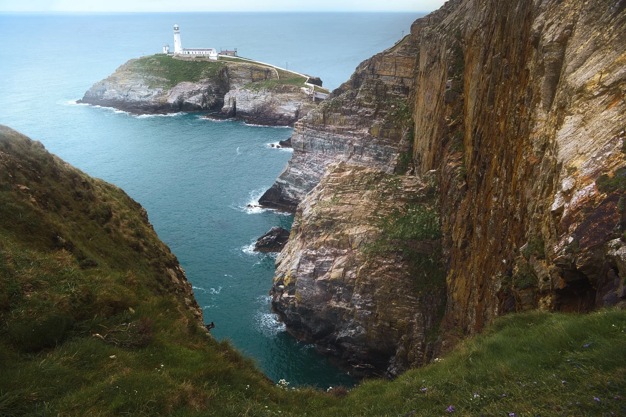
After circumambulating around Rhoscolyn Headland, we drove further up the coastline of Ynys Gybi to revisit a favourite of ours: South Stack. This is a tiny rocky island just off the cliffs of Ynys Gybi, and is home to a picturesque lighthouse. Access is via steep and winding steps that navigate down the sheer cliff face. Every now and then, you get incredible views across the cliffs as you head down the steps.
South Stack lighthouse, shot from higher up the steps. The lighthouse was constructed in 1809 and finally automated in 1983. To begin with, the sole means to traverse to the island was via a basket hung from a hemp rope. Subsequently, in 1828 an iron suspension bridge was constructed, which was then replaced in 1964 by a steel cable truss bridge. Nevertheless, in 1983 it became necessary to close the bridge to the public due to safety issues. Finally, after an aluminium bridge was built, the lighthouse was reopened for public access in 1997. At present, it has become a favoured tourist attraction, drawing many thousands of visitors annually.
Further south from the lighthouse, one can take the path from the RSPCB building down the cliff to Ellin’s Tower, then enjoy a wander along the cliff tops there. A sheer from near Ellin’s Tower gave me this dramatic composition looking back at South Stack and its lighthouse.
Elin’s Tower and, further, South Stack Lighthouse in the distance, with gorse (Ulex europaeus) flowering everywhere. Unusually, gorse in the spring has the strong scent of coconut. Elin's Tower is a Victorian stone tower. This castellated architectural extravagance, initially employed as a summer residence, was constructed between 1820 and 1850 for the prominent Stanley family of Penrhos. It derives its name from Elin (anglicised as "Ellen"), the Welsh spouse of the 19th-century statesman William Owen Stanley.