
Sedbergh, Yorkshire Dales, Summer
It’s summer! Y’know what that means? Wild flower meadows.
It’s summer! Y’know what that means? Wild flower meadows.
We’re rather fortunate to live where we do, sandwiched between abundant nature. You can take your pick of beautiful places to see wildflower summer meadows. A particular favourite is Swaledale in the Yorkshire Dales.
But I can also recommend the Sedbergh meadows underneath the Howgills.
We usually start this hike from Sedbergh town itself, but this time we started from Straight Bridge, walking away rather than into the sun.
Sedbergh is pretty enough anyway, but in the summer it becomes positively idyllic. And the meadows around the town were filled with wildflowers.
All photos taken on my Sony α7ii using my Sony 24-240mm F3.5-6.3 OSS zoom and Rokinon 14mm f2.8 ED AS IF UMC prime lenses. RAWs developed in Lightroom, edited in Photomatix and Photoshop.
Sedbergh, Yorkshire Dales, Summer by Ian Cylkowski is licensed under CC BY-NC-SA 4.0![]()
![]()
![]()
![]()
Following the path alongside the River Rawthey, a beautiful field full of buttercups stopped us in our tracks.
So did these mushrooms. These are possibly Dryad’s Saddle, or Cerioporus squamosus.
A Kendal Rough Fell yow enjoying the summer sun in the meadows.
A pair of geese, following each other around the fields.
New Bridge, which is quite a funny name given that it was built in the 1700s. A lush scene framing this gorgeous structure.
There’s plenty of horses about at the moment as travellers make their way to the Appleby Horse Fair. One particularly shaggy fella posed for me in a field full of flowers, and I couldn’t say no.
After a brief pit stop and refreshment in Sedbergh town, we continued the hike. The trail circumnavigates Castlehaw and climbs up the hillside underneath the Howgills. A very dry Settlebeck Gill provides a leading line in between these gnarly old trees.
Out into the open, fields full of flowers surrounded us. Passing clouds temporarily darkened the summit of Knott, whilst sheep and their lambs happily graze on the meadows below.
Further along the trail, a field of curious bullocks idly stare at us as we made our way towards Ghyll Farm.
Just before you reach Ghyll Farm the trail narrows into a beautiful little lane, surrounded by hedgerows and old trees. It created a natural frame that I made a composition of.
Beyond Ghyll Farm, you continue southeast towards Stone Hall, a Grade II* listed building. Formerly a farmhouse, it dates from 1695.
Between Stone Hall and Ellerthwaite, the wildflower meadows just got better and better. One particular field was absolutely chock full of them. I nabbed a shot of Lisabet admiring the buttercup fields, a timeless scene.
We spotted this old tree, host to a load of bracket fungi, so I equipped my ultra-wide lens in order to make a composition of the tree, the fungi, the buttercup meadow and the Howgills. Success!
The cloud cover was beginning to thicken, but pockets of sun still broke through. A distant scene looking south towards the Dent fells made me zoom right in.
At Ellerthwaite we came across this magnificent field full of buttercups. I spotted these tracks winding through the field and waited for the sun to burst through, illuminating the field whilst the distant hills darkened under the clouds.
Beyond Buckbank the trail follows the trees above the River Rawthey back to Straight Bridge. Another beautiful meadow lined with farm tracks, with Lisabet ahead, gave me my final composition.
Did you enjoy these photos?

The Northern Reaches of Lancaster Canal, Cumbria, Spring
A wet Bank Holiday weekend finally gave way to a glorious evening.
A wet Bank Holiday weekend finally gave way to a glorious evening.
With little time off left, we decided on familiar jaunt that nevertheless is always a pleasure to do: Lancaster Canal’s Northern Reaches.
The Northern Reaches is a part of Lancaster Canal that’s cut off from the rest of the UK’s canal network. In the 1960s, the construction of the M6 motorway north of Carnforth bisected the northern section of the Lancaster Canal, isolating the Tewitfield terminal and leaving the disconnected remnants of the canal to be reclaimed by the natural environment.
For this simple hike we elected to take the route south from Millness Bridge to where the M6 cuts off the canal near Duke’s Bridge. This route offers foliage galore, waterfowl, insect heaven, and fantastic views towards the imposing shape of Farleton Knott.
All photos taken on my Sony α7ii using my Sony 24-240mm F3.5-6.3 OSS zoom lens. RAWs developed in Lightroom, tonemapped in Photomatix, and finalised in Photoshop.
The Northern Reaches of Lancaster Canal, Cumbria, Spring by Ian Cylkowski is licensed under CC BY-NC-SA 4.0![]()
![]()
![]()
![]()
The section of the trail between Millness Bridge and Moss Side is rather muddy and greasy, especially after all the rain we’ve had. However, once you emerge from the tunnel at Moss Side, this lovely view to Farleton Knott finally opens up.
A swan couple, busy feeding from the bottom of the canal, their fresh-faced cygnets milling about aimlessly.
Across the canal, this horse impassively stairs at us.
Nearer Duke’s Bridge, a load of local cows have found their way to the canal for a wee drink.
I zoomed in tight on this beaut, giving us The Eye.
My favourite view anywhere on the Northern Reaches of Lancaster Canal. I managed to capture this reflection of Farleton Knott as the sun started to dip behind us.
A little further up a small gap in the overgrown foliage allowed for another composition of Farleton Knott.
The low evening light catching the tops of the foliage and the bridge. A delightfully idyllic scene.
This dark and shaggy horse posed for me near Marsden Farm underneath Farleton Knott. Couldn’t say no, really.
Did you enjoy these photos?
The Castles of Lllandeilo, South Wales, Autumn
We’re in South Wales for a fortnight!
We’re in South Wales for a fortnight!
It feels great to relax and have a proper break from the severely challenging year we’ve had.
Arriving at our holiday property Friday evening—after a gruelling 5-hour drive in the lashing rain—we woke up Saturday deciding to explore the area nearby where we’re staying around Llandeilo.
Llandeilo is a small town on the western edge of the Brecon Beacons National Park. It’s proper bonny. Evidence of Roman occupation from around 74AD has been discovered here; later on, the settlement was named after a famous Celtic monk—Saint Teilo—with the Welsh word llan meaning a church or monastery, hence the name Llandeilo (pronounced Shan-DAY-loh).
Owing to the long and rich Christian and royal history in the area, there are lots of castles nearby. We explored just two of them: Dinefwr and Castell Carreg Cennen, both impressive in their own right.
After Friday’s insane amount of rain, conditions on the Saturday were thankfully dry and epic.
All photos shot on my Fujifilm X-T2 using my Vivitar “Series 1” 28–105mm f2.8–3.8 zoom and Laowa 9mm f2.8 prime lenses. RAWs converted using Capture One for iPad, developed and finished in Affinity Photo for iPad.
The Castles of Llandeilo, South Wales, Autumn by Ian Cylkowski is licensed under CC BY-NC-SA 4.0![]()
![]()
![]()
![]()
Dinefwr Castle
Below the Dinefwr estate woods, beautiful autumn light and foliage wraps this gorgeous house.
Inside the keep of Dinefwr Castle (pronounced din-EH-vor). The advantage of a 9mm ultra-wide lens is that you’re able to capture a massive field of view in tight compositional situations like this.
Despite being largely built in the 13th century, a lot of the castle is still standing tall and strong.
It’s easy to see why a castle was built here. It’s position on a hill allows for extensive views over the Twyi valley.
It’s possible to climb up the battlements for even more extensive and panoramic views. Autumn colours are just starting to appear in South Wales at the moment.
Up on the highest point of the ruins, looking over the battlements and keep across the Twyi valley on a cloudy and windy day. Truly moody.
The winding stairway leading up is narrow and challenging, especially as the steps themselves are smooth and insubstantial. Amazing how much smaller people were back then.
There’s been a castle at this site since the mid-12th century, but most of present ruins can be attributed to the work of Rhys Gryg in the early 13th century. The castle came into English hands by the end of the 13th century courtesy of King Edward I of England.
By the end of the 15th century the castle came into the hands of Sir Rhys ap Thomas, who began the process of rebuilding and improving the castle. Sir Rhys was a favourite of King Henry VII, largely due to Rhys’ crucial involvement in the Wars of the Roses.
In the distance to the right you can see the turrets of Newton House, built in the 17th century with massive renovations in the 19th century. Around the time of Newton House’s construction, Dinefwr Castle was modified to serve as a summer house.
The castle and its environment were relatively quiet, with most people opting to check out Newton House instead, further to the north. As such, Lisabet and I had ample opportunity to properly explore and photograph the site.
Within the Dinefwr Estate woodland, I spied some gnarly trees covered in moss and quickly sought to make a composition of this gorgeous scene.
The sun appeared from the clouds once again, bathing this house in the woods in autumnal light.
Newton House and its turrets, a wonderful autumnal and historic scene.
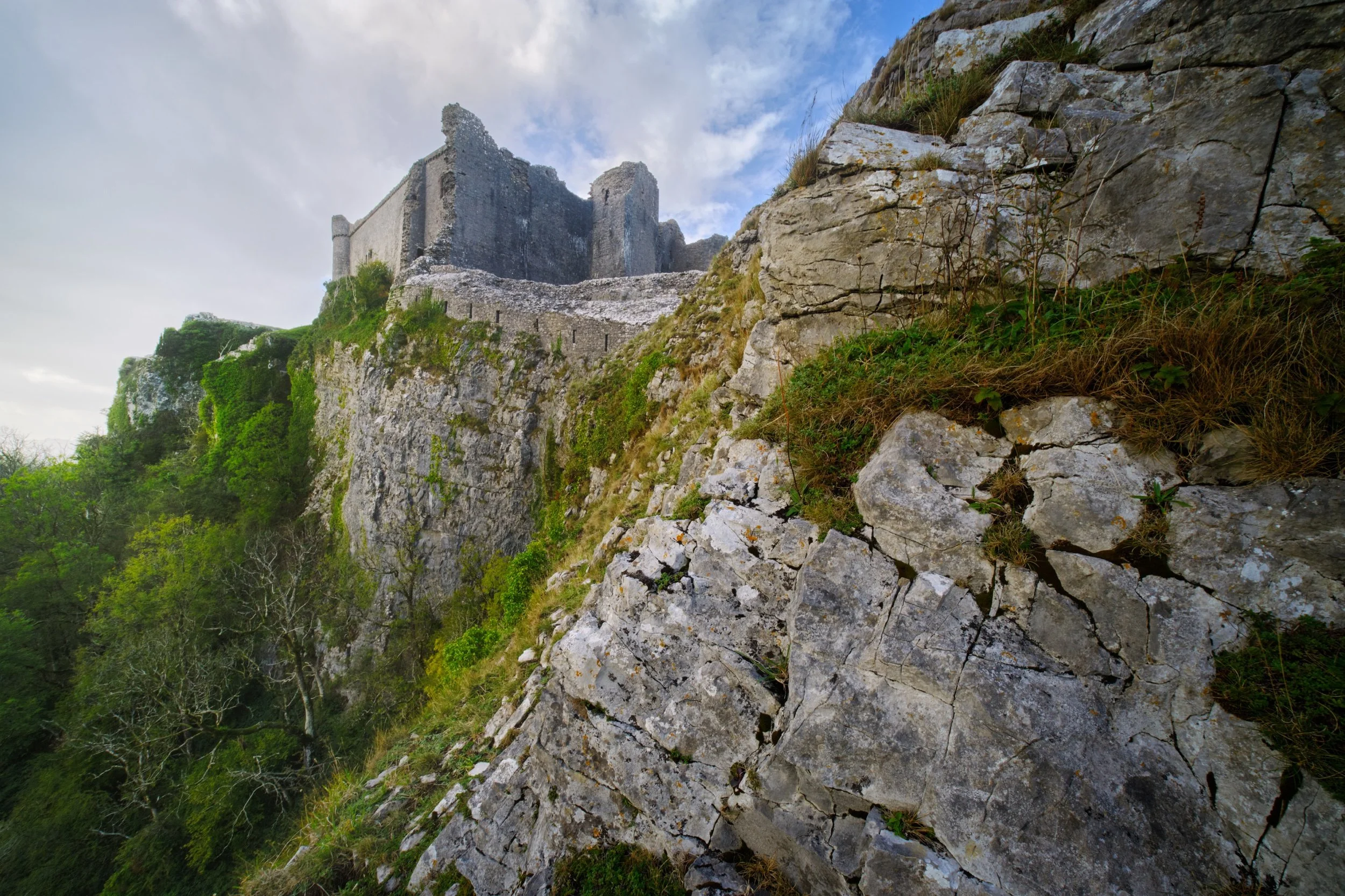
Castell Carreg Cennen
For our second trip for the day, we drove south east of Llandeilo into the Brecon Beacons National Park. Here one can find the impressive ruins of Castle Carreg Cennen, perched atop a high and might limestone crag above the River Cennen.
Rather then head straight into the ruins, Lisabet and I opted to scout around the shoulders of the crag. That’s how we found this ridiculous scene, with the castle perched on the limestone crag and a sheer 300ft drop down.
During our afternoon visit here the weather was much more inconsistent, alternating between brilliant bursts of light and sudden downpours. Whilst I was negotiating my way through the ruins, the sun once again burst through the racing clouds, illuminating this scene.
Castell Carreg Cennen was built in the 12th century, much like Dinefwr Castle, and similarly was claimed by the English through the conquest of King Edward I of England. These days the castle and its land is privately owned by the farm underneath it.
Frankly, one of the most stupendous and visually arresting castles I’ve ever seen.
Back at the farm beneath the castle ruins, a small herd of English Longhorn cows came to graze. Incredible creatures.
A beautiful shaggy coat with those imposing curling horns.
Did you enjoy these photos?
Conic Hill, Loch Lomond & The Trossachs, Scotland, Autumn
We’re back in Scotland, bayBEEEE!
We’re back in Scotland, bayBEEEE!
It feels so good to be back. Especially during the height of autumn, clearly the best time of the year.
We’ve had to contend with a variety of low pressure weather systems waving across the British Isles this week. This doesn’t seem to be easing. So, this morning, we got up and out to Balmaha. We wanted to get a hike up to the summit of Conic Hill (361 m/1,184 ft) before the forecasted rain storm arrived.
Thankfully conditions were favourable for long enough for us to enjoy the short, yet steep, hike up to Conic Hill and enjoy its amazing views.
All photos shot on my Fujifilm X-T2 using my Laowa 9mm f/2.8 and an adapted Pentax SMC 55mm f/2.0 lens. Developed using RNI Films’ Kodachrome film profiles.
Into the woods of Queen Elizabeth Forest Park, which nestle beneath the peaks of Conic Hill.
Some lovely soft light deep in the forest.
Especially this subtle spotlighting.
The West Highland Way starts to climb up as we look to exit the forest. Gorgeous light everywhere.
Vibrant reds of Rowan berries everywhere as we pop out of the forest and begin the steep ascent up towards the hill.
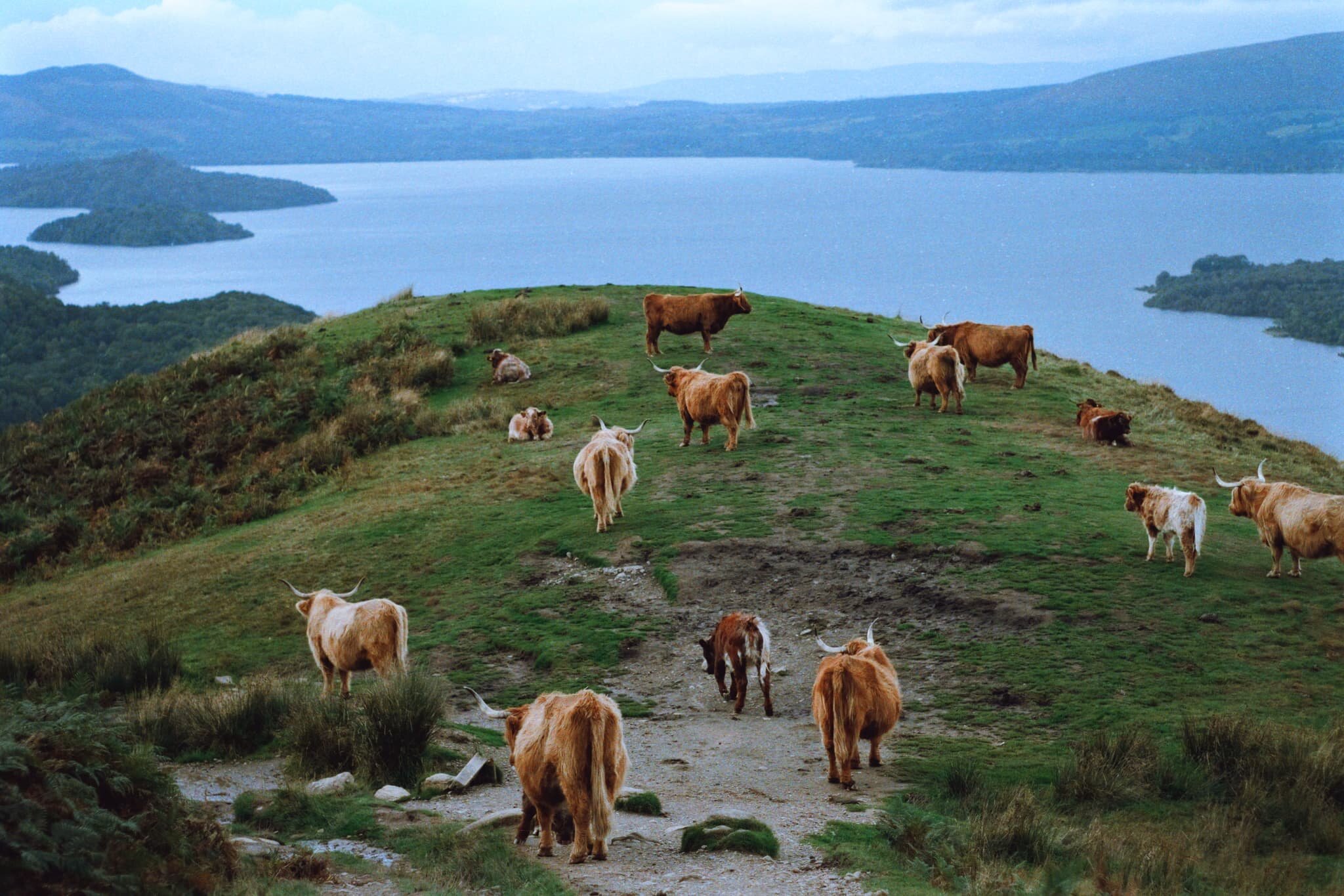
Our first sighting of a Highland Cow! Definitely in Scotland now…
I was very fortunate to snap this intimate moment between a Highland cow and her calf.
A herd of Highland cows and their calves, occupying a good outlook just off the West Highland Way.
The way up gets steeper. Though not busy, there’s still plenty of people around.
Our target: Conic Hill. Looking mighty steep.
Another look back at the Highland cows. Pretty damn good view they’re enjoying; I can see why they’re there.
The view east from the summit of Conic Hill. Wowsers!
An 8-shot panorama from the summit of Conic Hill, looking down its ridge towards the islands of Loch Lomond and its western hills. Fantastic.
A 5-image panorama, taking in the views from Conic Hill towards the Arrochar Alps, the low clouds clipping their peaks.
Conic Hill, and the islands of Inchcailloch and Inchmurrin, mark the Highland Boundary Fault, where two prehistoric continents (one containing Scotland, the other containing England) smashed into each other. Absolutely fascinating.
Another panorama taking in the sweeping views on the way down the West Highland Way.
The last of the good light, before the rain storm came in.
Back into the Queen Elizabeth Forest. Time to get the ultra-wide 9mm lens out.
There’s something lovely about the soft light you get in woodland. No wonder “forest bathing” is a thing.
Thankfully this part of the forest is pitched with steps, I can imagine it turns into a cascade of waterfalls in wet weather.
I just loved the cris-crossing of these ferns.
Lovely forest light again as start to emerge from the woods back to the Balmaha car park.
What a crackin’ hike.
Newlands Valley, Lake District, Summer
On the Sunday following the Saturday, we threw caution to the wind and visited the Lake District for a solid hike.
On the Sunday following the Saturday, we threw caution to the wind and visited the Lake District for a solid hike.
Signs were looking good that, for a Sunday morning, the Lake District wasn’t looking too busy (use Safer Lakes to check the busyness of Lake District car parks). We drove to Keswick and plotted a hiking route from the town onto the Cumbria Way towards the Lingholm Estate, where we’d pause for refreshment. Then we’d continue on the Cumbria Way towards the foot of Catbells, and break off into the Newlands Valley, terminating at Little Town and circling back all the way to Keswick.
All in all, about 16 km and 25,000 steps. Pretty good.
It was a stupendously beautiful day in the Lake District, and the Newlands Valley in particular was looking absolutely incredible.
Please enjoy these photos.
All photos shot on my Fujifilm X-T2 using my three prime lenses: a Samyang 35mm f/1.2, a Laowa 9mm f/2.8, and an adapted Pentax SMC 55mm f/2.0 lens. Images were made 80% in-camera using a customised Velvia film simulation, with minor edits afterwards in Lightroom and Affinity Photo.
Crossing the Greta Bridge here signifies the start of our walk onto the Cumbria Way. Given the weather we’d had, the river was looking very low.
The Cumbria Way bisects an open field, with clear views towards the Newlands fells one way and the Skiddaw range the other.
Pure Lake District. Mountains above, Herdwick sheep below.
Hot Herdwick ewes and their lamb find shade wherever they can. They’re about ready for clipping (shearing) I reckon.
Just south of the village of Portinscale, you enter a heavily wooded area. This is all part of the Lingholm Estate, the centre of which is a Victorian mansion built in the 1870s by Alfred Waterhouse.
The grounds of Lingholm Estate, and especially the Walled Gardens and Kitchen, are beautifully maintained.
Beatrix Potter made sketches of the octagonal kitchen garden and referred to it as her original inspiration for Mr McGregor’s garden in The Tale of Peter Rabbit.
Rhododendrons and foxglove. Pretty colour contrasts.
Everything was looking so lush in the gardens.
A brief window of light penetrates the woodland canopy, illuminating this uprooted tree.
After popping out of Overside Wood you enter what is simply known as The Park, and are greeted with the northern ridge of Catbells (451 m/1,480 ft), one of the Lake District’s most famous mountains.
Our journey that day did not involve Catbells, especially with the veritable train of people following the path up to the fell’s summit. Instead we took the minor road around the mountain’s western shoulder, heading towards the Newlands Valley. Already, the views look wonderful.
One of Keswick’s more familiar sights is the knobbly profile of Causey Pike (637 m/2,090 ft).
Rowling End (433 m/1,421 ft) slightly obscuring Causey Pike with Birkrigg Farm below.
Looking back the way we came, with the massive Skiddaw range looming above Keswick. My lovely Lisabet looking, well, lovely!
Following the minor road around Catbells’ western shoulder, the views open up more and more, giving us extensive panoramas of the Newlands fells.
An ultra-wide perspective of our way forward as the Newlands valley opens up.
The fell in the centre that looks like it’s had a massive bite taken out of it is Robinson (737 m/2,418 ft). The name might seem unusual, given most fell and place names in Cumbria have Old Norse origins. Apparently the land that included the fell was purchased by a Richard Robinson centuries ago. The fell, at the time unnamed, became known as Robinson’s Fell, and eventually shortened to Robinson.
I suspect this minor road was once a miner’s road (see what I did there?). According to the OS Map, ahead of us at Yewthwaite was some disused old mining works beneath Maiden Moor (576 m/1,890 ft).
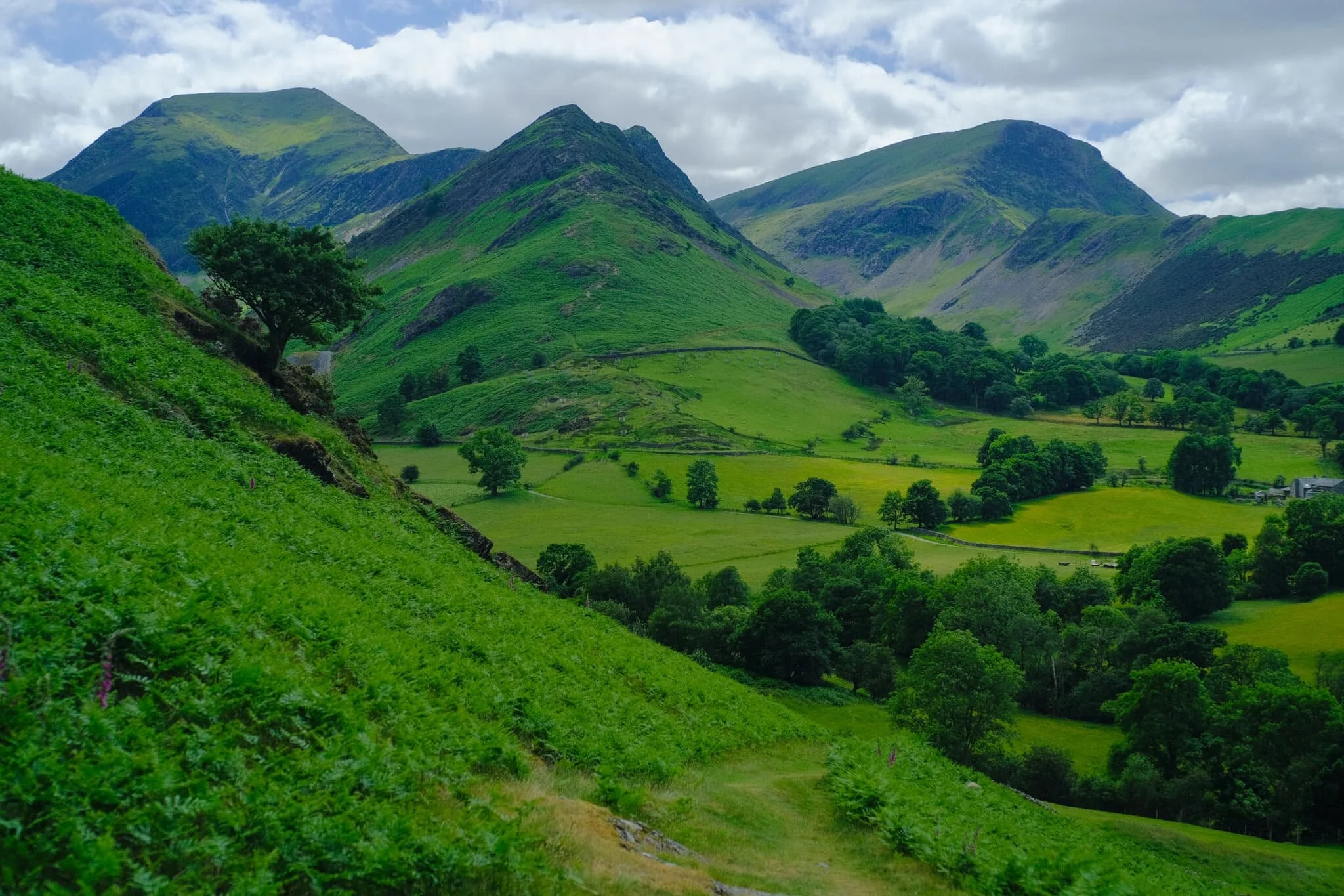
We followed the trail through the old mines and onward towards Little Town. Ahead of us, Ard Crags’ (581 m/1,906 ft) pointy profile is revealed. But what I’m looking for is just around the corner of High Crags…
And there it is. In my mind, one of the best views in all of Lakeland. Dale Head (753 m/2,470 ft) on the left, Hindscarth (727 m/2,385 ft) in the middle, and Robinson on the right.
Looking back the other way, we are treated to another gorgeous Lakeland summer scene. Herdwick sheep in the valley bottom, the Skiddaw range above.
We stopped for refreshment and delicious ice cream at Catbells Café in Little Town. Ard Crags, like a toddler amongst the grown-ups, still very much demanded our attention. Not a bad spot for refreshments, eh?
After pausing at Little Town we circled back and followed the trail all the way back towards the Cumbria Way and Keswick. This part of the trail is closer to the valley bottom and more open, giving us different views entirely.
A pleasing composition of ancient trees, farm fence and gate, and the Skiddaw range.
Lots of the standalone trees around this part of the Newlands Valley I suspect are rather old, and remnants from when this valley was cleared of woodland by Viking settlers.
It also means you find strange and unusual trees, such as this beauty. Ever seen a tree trunk like it?!
From one field into another, following an ancient lane back towards Skiddaw.
One final look back at the Newlands fells, with groups of Texel sheep and lambs dotted about.
Back on the minor road underneath Catbells. Lisabet grabs a rare selfie, with Blencathra looking mighty in the distance.
Stormwater Bridge, a suspended footbridge, indicates our approach is near Keswick. The Skiddaw range looms ever closer.
Herdwick lambs seeking shade from the warm day. They are born jet black, save for tufts of white around their ears. As they age, their face and legs turn white and their fleece becomes a dark, chocolatey brown. It’s not until they’re 2-3 years of age that they get their first clip (shear), which reveals the characteristic grey Herdwick fleece underneath.
Zen Cow is contemplating existence…
Keswick town was busy. Time to navigate through the crowds in order to get back to the car.
What a wonderful day it was.
Cunswick Fell, Lake District, Summer
Sometimes, as an Englishman, you just need to have a proper English Countryside experience.
Sometimes, as an Englishman, you just need to have a proper English Countryside experience.
For one reason or another, I’ve not been feeling 100% mentally and emotionally this week. Saturday arrived as a glorious summer’s day. We knew the Lake District would be absolutely heaving with people. Instead, we opted for a local 9km walk around the Cunswick Fell area.
It was just the tonic. The sun was warm, but a gentle cool breeze made things comfortable. The fields and meadows were bursting with tall grasses and wildflowers. The atmosphere was crisp and the distant fells were clear as a bell. One of the those hikes where you can’t take a bad photo and makes you feel truly grateful.
All photos taken on my Fujifilm X-T2 using my three prime lenses: a Samyang 35mm f/1.2, a Laowa 9mm f/2.8, and an adapted Pentax SMC 55mm f/2.0. Images were 80% made in-camera using a customised Velvia film simulation, with minor edits afterwards in Lightroom and Affinity Photo.
After leaving the Cumbria Wildlife Trust HQ, where we parked, we took the trail off the road and through the fields. Immediately, scenes like this greeted us. Just pure bucolic perfection.
Buttercups everywhere, and the Kentmere fells so clear you could almost reach out and touch them.
Lisabet snapping as happily as I was.
Near Halhead Hall Farm, a trail through the woods underneath Cunswick Fell takes you 60 m up towards the fell.
Up on Cunswick Fell, the views soon start to open up. Here is the view looking east towards the Howgills.
The Lake District fells across the Lyth Valley from Cunswick Fell. It doesn’t get a lot better than this.
We scanned around the western shoulder of Cunswick Fell, looking for the trail down Scar Wood towards Cunswick Tarn.
This is the limestone woods of Scar Wood, underneath Cunswick Scar. It takes you down to the Lyth Valley.
The trail then leads through the edge of Ash Spring Wood, filled with wild garlic.
And then you pop out of Ash Spring Wood to be greeted with endless fields of tall grass and the Coniston Fells.
Over the wall near us, this gorgeous Holstein Friesian was inching closer, being as inquisitive as cows are.
The way to Cunswick Hall, which is where we join the ancient country road Gamblesmire Lane back towards Cunswick Fell.
Happy cows, basking in the sun.
Just ridiculous views, no matter which way you look.
Looking back down Gamblesmire Lane, the Lake District fells looking crisp as ever even with the extra cloud cover.
A Hawthorn-lined track that leads back to the summit of Cunswick Fell.
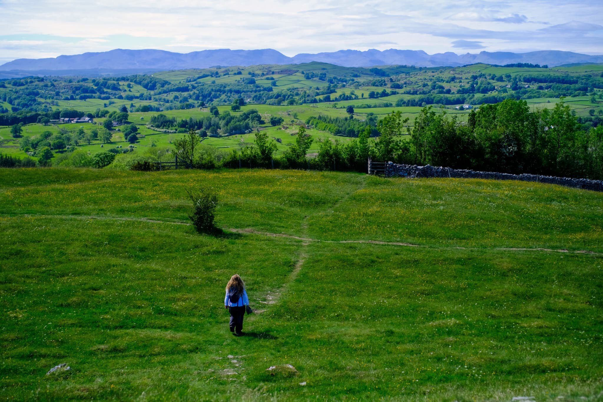
My lovely little Lisabet, leading the way back down the woods towards our car.
Just one of those perfect English countryside summer days.