Barnard Castle, County Durham, Spring
Apologies for the delay since my last post.
Apologies for the delay since my last post.
Things have been on the change again, personally. Also, this last week I’ve endured a rather nasty stomach bug. The less said about that the better.
A couple of weekends ago, Lisabet and I decided to move away from countryside-based adventures and check a wee little town you may have heard of (if you’re British and follow the news): Barnard Castle.
The charming historical town gained unfortunate notoriety in 2020 when Dominic Cummings, the chief advisor to the British Prime Minister, was found to have traveled there with his family during the first UK lockdown of the COVID-19 pandemic. Given his close contact with the infected Prime Minister, Cummings was at a substantial risk of carrying the virus himself (he exhibited symptoms the following day). Media accusations of violating lockdown rules emerged, to which Cummings explained that he had driven to the town to test his eyesight in order to reassure his wife of his ability to drive them back to London the next day.
Regardless of all of that, Barnard Castle sits in a beautiful area, which we explored to also take in the sights of the ruins of Eggleston Abbey.
A moody day for photography.
All photos taken on my Fujifilm X-T2 using my Vivitar “Series 1” 28–105mm f2.8–3.8 zoom and Laowa 9mm f2.8 prime lenses. RAWs developed in Capture One for iPad, edited and finalised in Affinity Photo for iPad.
Barnard Castle, Country Durham, Spring by Ian Cylkowski is licensed under CC BY-NC-SA 4.0![]()
![]()
![]()
![]()
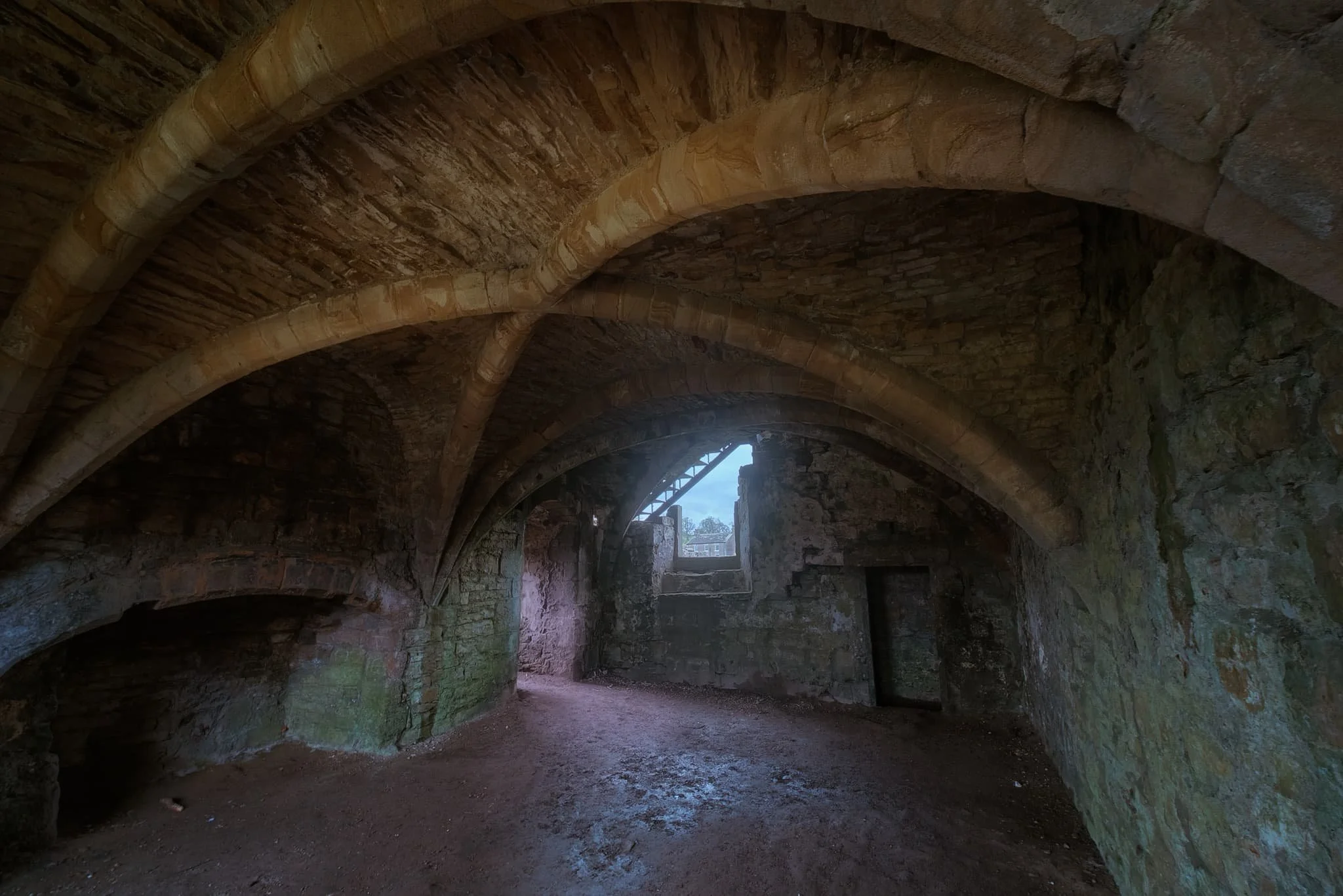
The circular round tower of the Barnard Castle itself, one of the main features of the ruins that still stands. Daffodils lined the path around the ruins on a moody day.
Barnard Castle, the town, is chock-full of yards (alleys) like this, which always draw my eye for a photo.
We found the streets of Barnard Castle to be well kept, with plenty of independent shops and eateries, occasionally peppered with some more mainstream brands.
Below the castle ruins this handsome bridge caught a sliver of golden afternoon light.
We followed the country road from Barnard Castle to Egglestone Abbey. The moody and changeable day followed us. Here a table-tomb pointed towards some of the last standing walls of the abbey ruins.
The abbey was constructed in the late 12th century by Premonstratensian monks. Like all other abbeys in England, it was dissolve din 1540 by King Henry VIII’s Dissolution of the Monasteries.
These days the ruins are in the custody of English Heritage, and access is free. I highly recommend a visit if you’re ever in the area.
Did you like these photos?

Stanley Ghyll Force, Lake District, Spring
After a sobering return from a beautiful week in the Highlands, it was time for a beautiful little jaunt in Eskdale.
After a sobering return from a beautiful week in the Highlands, it was time for a beautiful little jaunt in Eskdale.
I was also due to hang out with me Dad again. After arriving at Dad’s, he suggested checking out Stanley Ghyll Force, one of the Lake District’s largest waterfalls. I were game for that!
Stanley Ghyll Force is located in Eskdale, a gorgeous valley in the southwestern corner of the Lake District. The last―and only―time I visited Stanley Ghyll Force was back in 2017. I know this because I shot the waterfall with a Sigma dp0.
Back then, I was all on me own attempting to navigate a tricky gorge. However, on that occasion, I was able to get right to the bottom of the falls for some cracking.
A lot has changed in the intervening 5-6 years. For a start, you can’t get to the bottom of the falls anymore. The path has eroded and collapsed to the point that it’s too dangerous. Instead, the Lake District National Park have created an alternative route that scales up the sides of the gorge so that you can get above the falls. In addition, they’ve also cut back hectares of invasive rhododendron and constructed a fantastic viewing station above the gorge.
We enjoyed some fantastic light, and I had a grand day out with me Dad.
All photos taken on my Fujifilm X-T2 using my Vivitar “Series 1” 28‒105mm f2.8‒3.8 zoom, Super Ozeck 80mm‒210mm f4.5 zoom, and Laowa 9mm f2.8 ultra-wide prime lenses. RAWs developed in Capture One for iPad, edited in Affinity Photo 2 for iPad.
Stanley Ghyll Force, Lake District, Spring by Ian Cylkowski is licensed under CC BY-NC-SA 4.0![]()
![]()
![]()
![]()
The gorge that contains Stanley Ghyll Force is wonderfully mossy and vibrant. Here, a pocket of light illuminates a boulder field exposed in the woodland.
We passed a small tributary beck that was catching some wonderful light in the gorge.
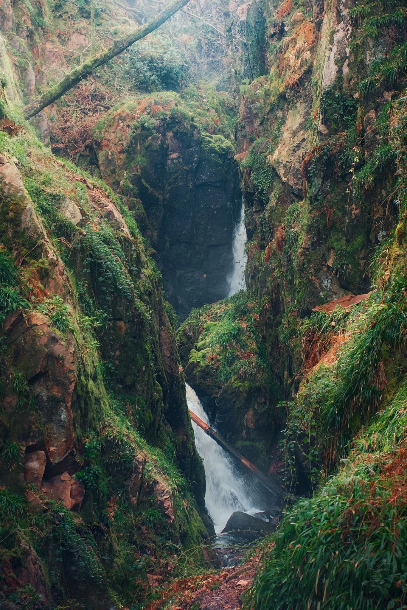
Eventually, the glory of Stanley Ghyll Force came into view. This was as close as we were allowed to get to it. Still some absolutely crackin’ light flooding into the gorge though.
After hiking up the new path made by the National Park, we found the new viewing station to check out the views it offered. And… wow. A sheer 150ft drop pulls your down the gorge and towards Stanley Ghyll Force. What a sight.
We followed the return track back down to the valley. As we did, me and Dad spotted some incredible light playing out on the distant Eskdale fells, and stopped to shoot photos like crazy.
Did you like these photos?
Oban, Argyll & Bute, Scotland, Winter
We’ve only ever been to Oban once before.
We’ve only ever been to Oban once before.
This was way back in Autumn 2014, when we first went into the Highlands of Scotland. On a particularly murky, misty, and wet day we drove away from the mountains and instead went to check out the nearest major town: Oban.
On that occasion, we were unimpressed. The place seemed drab and down on its luck.
On this trip, we decided to revisit Oban now that we had great light and clear blue skies. Oh boy, did we completely misjudge Oban. It’s a beautiful little town that enjoys terrific sea views across to Kerrera Island and the Isle of Mull beyond. It also enjoys lovely independent shops, top cafés, and gorgeous restaurants.
Amazing what better weather and 10 years can do.
All photos taken on my Fujifilm X-T2 using my Vivitar “Series 1” 28–105mm f2.8–3.8, Laowa 9mm f2.8, and Super Ozeck 80–205mm f4.5 lenses. RAWs converted in Capture One for iPad, developed using RNI Films’ Kodachrome film profiles, and finalised in Affinity Photo 2 for iPad.
Oban, Argyll & Bute, Scotland, Winter by Ian Cylkowski is licensed under CC BY-NC-SA 4.0![]()
![]()
![]()
![]()
Round the corner from where we parked, Oban Distillery is a beautiful building. The distillery was established in 1794, before there was even a town around it.
Our first order of the day was to hike up the hill behind Oban to check out the area’s most well-known landmark, McCaig’s Tower.
The way to McCaig’s Tower. It was built in 1897, commissioned by wealthy banker John Stuart McCaig as a monument to his family and to provide work for the local townsfolk. He was also the tower’s architect.
Out of the tower’s western side, you can enjoy expansive views across the Inner Firth of Lorn towards Kerrera Island and the Isle of Mull. Regular ferry trips courtesy of CalMac are available to the various islands near Oban.
One of these days we’ll have to check out some of the small isles you can visit from Oban.
McCaig’s Tower has 94 lancet arches, one of which I utilised as a literal compositional frame towards the mountains on the Isle of Mull.
Mr. McCaig commissioned the building of the tower at a cost in 1897 of £5,000 Sterling… that’s over £500,000 in today’s money.
The tower was built between 1897 and 1902, when Mr. McCaig died of a cardiac arrest. Construction of the tower promptly stopped, with only the outer walls completed.
Mr. McCaig planned for a museum and art gallery with a central tower to be incorporated. Inside the central tower he wanted to commission statues of himself, his siblings and their parents. None of this happened due to his death and the contesting of his Will. Nevertheless, I like that inside the tower a garden has been allowed to form.
Back down at the shore we gently meandered around the town’s coastline, looking for shots before stopping for lunch.
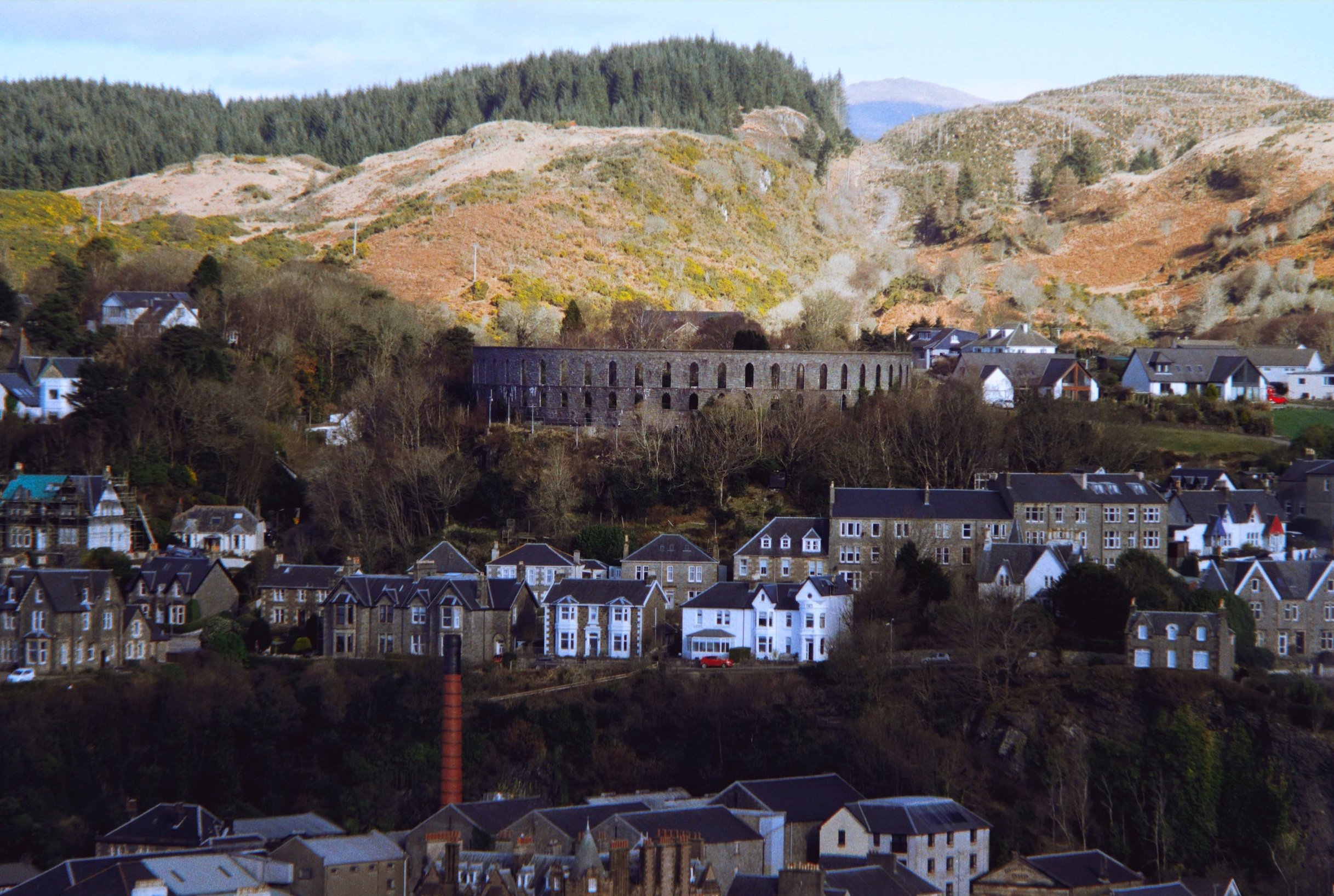
After a delicious lunch at Ee-Usk (which included the freshest oysters I’ve ever had), our next plan was to head up another hill above the town: Pulpit Hill.
A short and sharp climb up onto Pulpit Hill gave us tremendous views of the town, like this. Even from here, McCaig’s Tower is easily visible, as is the Oban Distillery’s bright red chimney.

From this vantage point I hastily equipped me Super Ozeck 80–205mm zoom lens for long compositions. The day was so crisp you could even make out Ben Cruachan (1,126m/3,694ft), 26-miles away.
Zooming in across the Inner Firth of Lorn. Bottom left is the northern tip of Kerrera Island, followed by the tiny islet of Maiden Island in the centre. In the distance is the uplands of the Isle of Mull.
Along the northern coastline of Oban one can find the ruins of Dunollie Castle, which enjoys a great lookout towards the uplands on the Isle of Mull. There’s been a fortification where the castle sits since the Early Middle Ages, but the current ruins date from the 12th or 13th century.
A super-zoomed in shot of upper Oban, with McCaig’s Tower visible and the craggy uplands above.
Hutcheson’s Monument on Kerrera Island, acting as a beacon pointing the way towards the Isle of Mull.
Did you enjoy these photos?

Glencoe Lochan & Glen Etive, Scotland, Winter
Somewhere new and somewhere old.
Somewhere new and somewhere old.
The draw of Glen Etive is always strong, especially with those world-famous views towards Buachaille Etive Mòr. But before we revisited what is quickly becoming known as the “Skyfall valley”, we wanted to check out somewhere new (to us).
At the foot of Glencoe, beneath the prominent peak known as the Pap of Glencoe, there’s a fair amount of woodland one can enjoy. Within that woodland one can find a small tarn known as Glencoe Lochan.
It’s super easy to get to and thankfully, on this occasion, it offered us almost perfectly clear reflections of the surrounding mountains.
After exploring the lochan, we then drove downGlen Etive for compositions of the “the Buckle” and more.
An absolute corker of a day.
All photos taken on my Fujifilm X-T2 using my Vivitar “Series 1” 28–105mm f2.8–3.8 zoom and Laowa 9mm f2.8 lenses. RAWs converted and corrected in Capture One for iPad, developed using RNI Films’ Kodachrome film profiles, then finalised in Affinity Photo 2 for iPad.
Glencoe Lochan & Glen Etive, Scotland, Winter by Ian Cylkowski is licensed under CC BY-NC-SA 4.0![]()
![]()
![]()
![]()
Glencoe Lochan
From the village of Glencoe, the Pap of Glencoe is ever-present. The word “pap” comes from Middle English, meaning “breast”.
In the distance, this magnificent stag was happily chewing cud and enjoying the winter sun light.
The beck below the woods looked absolutely gorgeous; the water was unbelievably clear. One to think about a swim in.
The woodland beneath the Pap was chock-full of delightful scenes like this.
Soon enough we arrived at the lochan to find perfect reflections of the various mountains around.
Glencoe Lochan was planted in the 1890s by a Donald Alexander Smith, 1st Baron Strathcona and Mount Royal, using trees from the Pacific Northwest of Canada. He did this to alleviate his wife’s homesickness, who was missing Canada after moving to Scotland.
In the morning winter sun, reflections of Beinn na Caillich looked sublime.
Looking west from one of the many jetties dotted around the lochan, the pyramidal peak of Sgorr Dhearg (1,024m/3,359ft) was looking crisp.
I spotted an opportunity to focus-stack some evergreen foliage along Glencoe Lochan’s eastern shore, the reflections leading the way towards Sgorr Dhearg.
I bet this place looks absolutely insane in autumn.
Glen Etive
After stopping off at the Glencoe Ski Resort cafe for a bite and a coffee, we made our way towards Glen Etive. But first, I just had to nab this iconic building and composition. This is Blackrock Cottage, a private building that’s been featured in hundreds of photos with “the Buckle” behind it.
At the top of Glen Etive, the River Coupall crashes into the River Etive in a series of impressive cascades. It is perhaps the photographer hotspot for photos of the Buckle, and I’m no different. How can you say no to a scene like this?
Lisabet and I clambered up the River Coupall, seeking compositions of the Buckle.
To date, this is perhaps the finest shot of the Buckle I’ve ever taken. I knew there had to be a reflection in the river somewhere…
Down at the foot of Glen Etive, right on the shores of Loch Etive, I spot this little group of trees beautifully framing Stob Dubh.
Those same trees act as a leading device in another composition involving Stob Dubh.
Directly opposite our shore, Ben Starav (1,078m/3,536ft) dominates the eastern shore of Loch Etive.
The final composition of the day. Beautiful Scots pines and Stob Dubh in the distance.
Did you enjoy these photos?

Glen Nevis, Lochaber, Scotland, Winter
The grandest valley beneath the tallest mountain.
The grandest valley beneath the tallest mountain.
The last time we visited Glen Nevis was way back in Autumn 2014, which was our very first time in the Glencoe/Lochaber area. This was in the prime of my HDR days.
Almost 10-years on, we returned with greater fitness and better vision. We elected to take the valley bottom riverside walk from the Ben Nevis Visitor Centre all the way to Polldubh falls and back. A solid 12–13km hike.
The section from the visitor centre to Polldubh falls was definitely not fun in places; the trail often became indistinct, with areas of sludgy bog and slippery mud. Nevertheless, the views were simply astounding wherever you looked, and we were blessed once again with glorious weather.
Photos taken on my Fujifilm X-T2 using my Vivitar “Series 1” 28–105mm f2.8–3.8 zoom and Laowa 9mm f2.8 ultra-wide lenses. RAWs converted in Capture One for iPad, developed using RNI Films’ Kodachrome film profiles, and finalised in Affinity Photo 2 for iPad.
Glen Nevis, Lochaber, Scotland, Winter by Ian Cylkowski is licensed under CC BY-NC-SA 4.0![]()
![]()
![]()
![]()
A relatively new and modern bridge crosses the River Nevis from the visitor centre and leads you along the riverside trail. A lot of people take this route to begin their ascent up all 1,345 m (4,413 ft) of Ben Nevis.
Following the riverside trail, the view down the glen opens up and reveals the massive shape of Sgùrr a’ Mhàim (1,099 m/3,606 ft). Its name means “rocky peak of the rounded hill”.
Despite the bright winter sun, it was still cold enough in the shade to freeze the water running down the valley sides.
After navigating a meander in the river, the neighbour of Sgùrr a’ Mhàim becomes visible: Stob Bàn (999 m/3,278 ft), which means “white peak”.
Nearing Polldubh falls, the path climbs up and away from the river. Doing so revealed this delightful composition towards Sgùrr a’ Mhàim, which I had to nab.
An abandoned, white-washed cottage. I don’t know if it’s used as a mountain bothy now or not.
Polldubh falls, with upper Glen Nevis in the distance. Quite an arresting sight, and developing a powerful waterfall.
Sgùrr a’ Mhàim is often mistaken to have snow around its peak. In fact, it’s usually white quartz you can see, which gives the mountain its lighter capped colour.
Heading back up the glen from the falls, the craggy shoulders of Meall an t-Suidhe (711 m/2,333 ft) are drenched in late afternoon winter sun.
I couldn’t resist this road shot featuring the two towering giants at the head of the glen. The road was quiet enough to allow us to walk alongside it all the way back to the visitor centre.
One last look back at Sgùrr a’ Mhàim before returning the visitor centre.
A challenging walk, in places, but a grand experience nevertheless.
Did you enjoy these photos?

The Lost Valley, Glencoe, Scotland, Winter
After nearly a decade, it’s time to tick this one off the bucket list.
After nearly a decade, it’s time to tick this one off the bucket list.
Early on in my photography journey—almost immediately after I learned about the wonders of Glencoe—I discovered and read about a “secret” valley above the main Glencoe valley itself.
It captivated me immediately.
This place is known in English as the Lost Valley or the Hidden Valley. In Scottish Gaelic it’s called Coire Gabhail, meaning “corrie of bounty” or “the hollow of capture”. Legend has it that this hidden valley was used by members of Clan MacDonald to hide cattle and other livestock. Whether the livestock was their own or belonging to others, we’ll never know.
The day dawn completely clear and very cold, with temperatures not breaking above freezing point. It’s not a long hike from Glencoe up into the Lost Valley, but it was definitely made harder with all the ice everywhere.
The reward, however, was more than worth it.
All photos taken on my Fujifilm X-T2 using my Vivitar “Series 1” 28–105mm f2.8–3.8 zoom and Laowa 9mm f2.8 ultra-wide lenses. RAWs converted using Capture One for iPad, developed in RNI Films using an Ektachrome 100 film profile, and finalised in Affinity Photo 2 for iPad.
The Lost Valley, Glencoe, Scotland, Winter by Ian Cylkowski is licensed under CC BY-NC-SA 4.0![]()
![]()
![]()
![]()
Parking up at the main car park at Glencoe, two of the Three Sisters of Glencoe immediately hold my attention. On the left is Geàrr Aonach (689m/2,263ft), and to the right is Aonach Dubh (892m/2,296ft). The snowy peak catching the light in the middle is Stob Coire nan Lochan (1,115m/3,658ft).
A vertical, and tighter, composition that allows the beacon of Stob Coire nan Lochan to really stand out.
As we began hiking up the trail in between Beinn Fhada and Geàrr Aonach, the sheer ridge face of Aonach Eagach was being drenched in morning wintersun.
The trail in between the two sisters involves careful stepping and scrambling as you’re essentially climbing alongside, and above, a gorge. The falls in the gorge were looking icy cold.
After much slipping, scrambling, and an inadvertent dunk in the river, we ascended above the rake to be greeted with this. Coire Gabhail, the Lost Valley. What a sight!
My longer lenses allow me to really zoom in tight on particular scenes within a grand vista. Here, I enjoyed the line created by the shadow of the valley side as it frames the golden crags and leads towards the snowy peaks of Stob Coire Sgreamhach (1,072m/3,517ft).
Despite the icy conditions of winter, there were still a fair few people about. A small party of Spanish-speaking people were elated to have made it to the Lost Valley.
Despite the incredible sight of the snowy peaks at the head of the Lost Valley, directly above you Beinn Fhada’s crags lean peerlessly over you, reminding you of just how small you are.
I located a small waterfall trickling down Beinn Fhada’s flanks that was freezing up. It’s little pool below already comprised of shards of ice.
A bit of ice-cold scrambling was in order to nab this composition with my ultra-wide 9mm lens, but I enjoy it.
With my 9mm lens still equipped, I went on the hunt for more subject matter that would be suitable for ultra-wide compositions. This boulder field with a single tree in the middle caught my eye and I lined up the shot.
Another dead tree covered in frozen moss and lichen made for a nice ultra-wide focus stacked composition.
I clambered along the valley side a little more to get past the trees and find a unhindered view of the Lost Valley.
One last look back at those magnificent peaks of the Lost Valley before gingerly scrambling back down the gorge again.
What an experience. Never to be forgotten.