
Oxenber & Wharfe Woods, Yorkshire Dales, Spring
It’s been nearly a month since my last post.
It’s been nearly a month since my last post.
I must apologise for that. Times, they are a’ changin’.
To start, we moved house! That in itself has consumed most of my time and energy, as house moves usually do. Thankfully we’re now all settled in and getting down to the important things in life, like looking at curtain textiles and measuring all the things.
With things settling back down a little, and the British weather drastically improving, we thought we’d try to capture the last of this year’s bluebells. Over the years we’ve found some proper lovely places to photograph bluebells, such as:
This time we tried somewhere new, to us, based on personal recommendation: the woods of Oxenber and Wharfe near Feizor.
And we were absolutely blown away.
Carpets of bluebells, some in ancient woodland, some out in the open with spectacular views to the likes of Moughton Scar and Ingleborough.
Happily, this was also my first full outing with my newly acquired Sony 24-240mm F3.5-6.3 OSS, courtesy of my Dad. This lens easily replaced five other lenses I had, which has significantly reduced my carrying load.
I hope you enjoy these photos as much as I enjoyed taking and editing them.
All photos shot on my Sony α7ii using my Sony 24-240mm F3.5-6.3 OSS zoom lens. RAWS edited in Lightroom, edited in RNI Films, and finalised in Photoshop.
Oxenber & Wharfe Woods, Yorkshire Dales, Spring by Ian Cylkowski is licensed under CC BY-NC-SA 4.0![]()
![]()
![]()
![]()

Our hike started from Austwick and we were soon on the easy well-defined trail towards the elevated Oxenber and Wharfe woods.
A beautiful Holstein Friesian lady, basking in the glorious sunshine.
We followed Wood Lane as the trail started to ascend. Looking back across the segmented fields towards Robin Proctor’s Scar and the Norber Erratics.
The signage was clear enough as to where we needed to go.
Soon enough we began the short and sharp ascent off Wood Lane and into Oxenber Wood. Bluebells everywhere.
This area of woodland and pasture was once an important quarry and source of timber for Austwick. Now it’s marked as an SSSI and largely left to its own devices.
Open areas of former pasture meant acres of bluebells, out in the open, enjoying views towards the likes of Moughton Scar and Ingleborough.
A carpet of bluebells with Moughton Scar on the left and Bargh Hill on the right.
Higher up, more former pasture land has given way to more bluebells. I found this solitary limestone boulder covered in moss that made for a lovely composition.
In addition to all the bluebells were tracts of limestone pavement, much to my delight!
Entering the denser woodland of Wharfe wood, a small trail branched off, giving views towards Moughton Scar.
Wharfe wood’s thicker coverage meant for beautiful soft light and trees covered in moss and lichen.
A small trail heads deeper into Wharfe Wood, with a hint of yet more bluebells beyond. Our route was to exit out of the eastern end of the woodland, but not before I chanced upon this mystical scene.
Popping out of Wharfe Wood, the unmistakable shape of Pen-y-ghent quickly makes itself known to us.
The route now followed the Pennine Bridleway towards Feizor. To the left are the shoulders of the limestone hills above Feizor.
This year’s spring lambs, of the Swaledale kind, quickly scampered to their mums.
On our descent to Feizor I spotted this little cottage and its field covered in buttercups.
The rest of the route back to Austwick was simple enough, just follow the Pennine Bridleway from Feizor to Austwick. This ancient country lane was lined with wild garlic (Allium ursinum) and its delicious smell.
The collapsed ruins of Meldings Barn, with a doorway still standing on its own.
Back at Austwick, the local cows gently made their way to Austwick Beck for a cool down and a drink to relieve from the warm spring day.
Did you enjoy these photos?

Feizor, Yorkshire Dales, Spring
I don’t explore the Yorkshire Dales enough.
I don’t explore the Yorkshire Dales enough.
After finally getting over my post-Skye mourning and depression period, it seemed like spring finally arrived in Northern England.
Aware of how busy the Lake District would be, we instead ventured east to the Yorkshire Dales. We quickly realised that we hadn’t explored the Feizor area of the Dales in a long time, like maybe 7-years or so. Time to fix that.
Feizor (pronounced “FAY-zer”) is a tiny l’al hamlet between Austwick and Settle, and easy to miss. Home to a few houses, a farm, and the famous Elaine’s Tearoom, rising high above the hamlet are the limestone fells of Pott Scar and Smearsett Scar. These were the focus of the day’s hike and exploration.
Pott Scar and Smearsett Scar were beautiful examples of limestone karst landscapes, but they also offered immense views to either the back of Ingleborough or the shapely Pen-y-ghent.
A super day.
All photos taken on my Sony α7ii using my Sony FE 28–70mm f3.5–5.6 OSS and Vivitar “Series 1” 70–210mm f2.8–4.0 zoom lenses. RAWs developed in Lightroom, then tweaked and finalised in Photoshop.
Feizor, Yorkshire Dales, Spring by Ian Cylkowski is licensed under CC BY-NC-SA 4.0![]()
![]()
![]()
![]()
A near-timeless scene in the heart of Feizor. Old stone buildings, dry stone walls, foliage everywhere, and the fells rising up behind.
This quaint scene, complete with old water pump, was something I couldn’t resist making a composition of.
Round the back of Pott Scar, before ascending, one can enjoy expansive views towards Pen-y-ghent, one of the Three Peaks of the Yorkshire Dales.
The squelchy slog up the fell was rewarded with beautiful views from Pott Scar towards Smearsett Scar.
Fin-like clints and grikes of limestone made for a nice leading line towards Smearsett Scar.
Nearer the edge of Pott Scar, I focus stacked these bare limestone edges as they curved off into the distance towards Smearsett Scar.
From the summit of Smearsett Scar, the full extent and shape of Pott Scar is revealed. The day was brightening up too, albeit with a haze.
The summit of Smearsett Scar offers a bounty of limestone clints and grikes that I want to make compositions of.
Another variation from the summit of Smearsett Scar, using the exposed clints and grikes as a leading line towards Pott Scar.
Back down the back of Pott Scar, drafting clouds cast dancing shadows across Moughton Scar and the back of mighty Ingleborough, another one of the Three Peaks of the Yorkshire Dales.
Plenty of teeny Swaledale lambs about, hastily retreating back to their mums as we followed the track back to Feizor.
The single road that winds its way through Feizor.
A super-zoomed in composition of the back of Ingleborough, taken from the small lane between Feizor and Buck Haw Brow, light dancing across the karst features of the land.
Did you enjoy these photos?

Trotternish Peninsula, Isle of Skye, Scotland, Spring
The last series of photos from our Skye spring 2024 trip.
The last series of photos from our Skye spring 2024 trip.
There’s a part of me that doesn’t want to post these, because it concludes in a way that we’re no longer on Skye.
And that is always painful.
For this post, I’ve assembled a rag-tag of photos taken from around Skye’s Trotternish peninsula that didn’t really fit in with other posts. This includes:
Duntulm Bay, with the epic ruins of Duntulm Castle perched on top of cliffs of volcanic sill
The ridiculously clear views we got from near the Flodigarry coast, across the sea to the Torridon mountains on the mainland
I hope you enjoy these photo as much as I enjoyed seeing and taking them.
All photos shot on my Sony α7ii using my Pentax SMC 28mm F3.5 prime lens and Vivitar “Series 1” 70–210mm f2.8–4.0 zoom lens. RAWs developed in Lightroom, then edited and finalised in Photoshop.
Trotternish Peninsula, Isle of Skye, Scotland, Spring by Ian Cylkowski is licensed under CC BY-NC-SA 4.0![]()
![]()
![]()
![]()
The epic ruins of Duntulm Castle, perched on top of basalt cliffs nearly 100ft above the surf. Southwest of the ruins, the coast is made of volcanic sill intrusions, criss-crossing joints that make for wonderful compositions.
Further west away from the castle ruins we could even spot across the sea here, known as the Little Minch, the islands of Lewis and Harris. I couple of crystal clear rock pools helped me create some sort of coherent composition from the chaos of rock joints.
Closer to the castle ruins, the sun broke out from the clouds above the Quiraing, giving fantastic side light to this scene. These ridged tufts of grass made for a nice compositional leading line into the scene.
From Flodigarry, above Loch Langaig, a small ruin made for a nice composition, mimicking the shape of the distant mountains.
We were astounded when stopping at Flodigarry to see crystal clear views across the sea towards the Torridon mountains on the mainland. So clear you almost felt you could reach out and touch the mountains.
Further along the mainland, the unmistakable shape of Slioch (“the spear”), above Loch Maree, is immediately apparent, standing 3,219 ft above the sea.
Did you enjoy these photos?
Oronsay, Isle of Skye, Scotland, Spring
We’ve only been to the tiny isle of Oronsay once before.
We’ve only been to the tiny isle of Oronsay once before.
This was back in autumn 2020, before the 2nd pandemic lockdown happened.
Conditions on that occasion were cloudy, flat, and grey. But still, the scenery and views were stunning and we vowed to return again.
And so we did, this time with bright spring skies. A world of difference!
Oronsay can be found in Loch Bracadale, along with lots of other little islands, sandwiched in between the Duirinish and Minginish peninsulas. It’s possible to access Oronsay on foot via a tidal causeway consisting of ankle-breaking fist-sized rocks.
Though only 44 acres in size, it features cliffs 240 ft high, which means it offers incredible views to either the cliffs and hills of the Duirinish peninsula, or the cliffs and Cuillins of the Minginish peninsula.
We didn’t see another soul.
All photos taken on my Sony α7ii using my Pentax SMC 28mm F3.5 prime and Vivitar “Series 1” 70–210mm f2.8–4.0 zoom lenses. RAWs developed in Lightroom using RNI Films’ Kodachrome film profiles, edited and finalised in Photoshop.
Oronsay, Isle of Skye, Scotland, Spring by Ian Cylkowski is licensed under CC BY-NC-SA 4.0![]()
![]()
![]()
![]()
From the mainland at Ullinish it’s a simple, if squelchy, walk from the settlement to the coast. The way to Oronsay then becomes clear; at low tide, the sea is parted by a causeway of boulders and rocks.
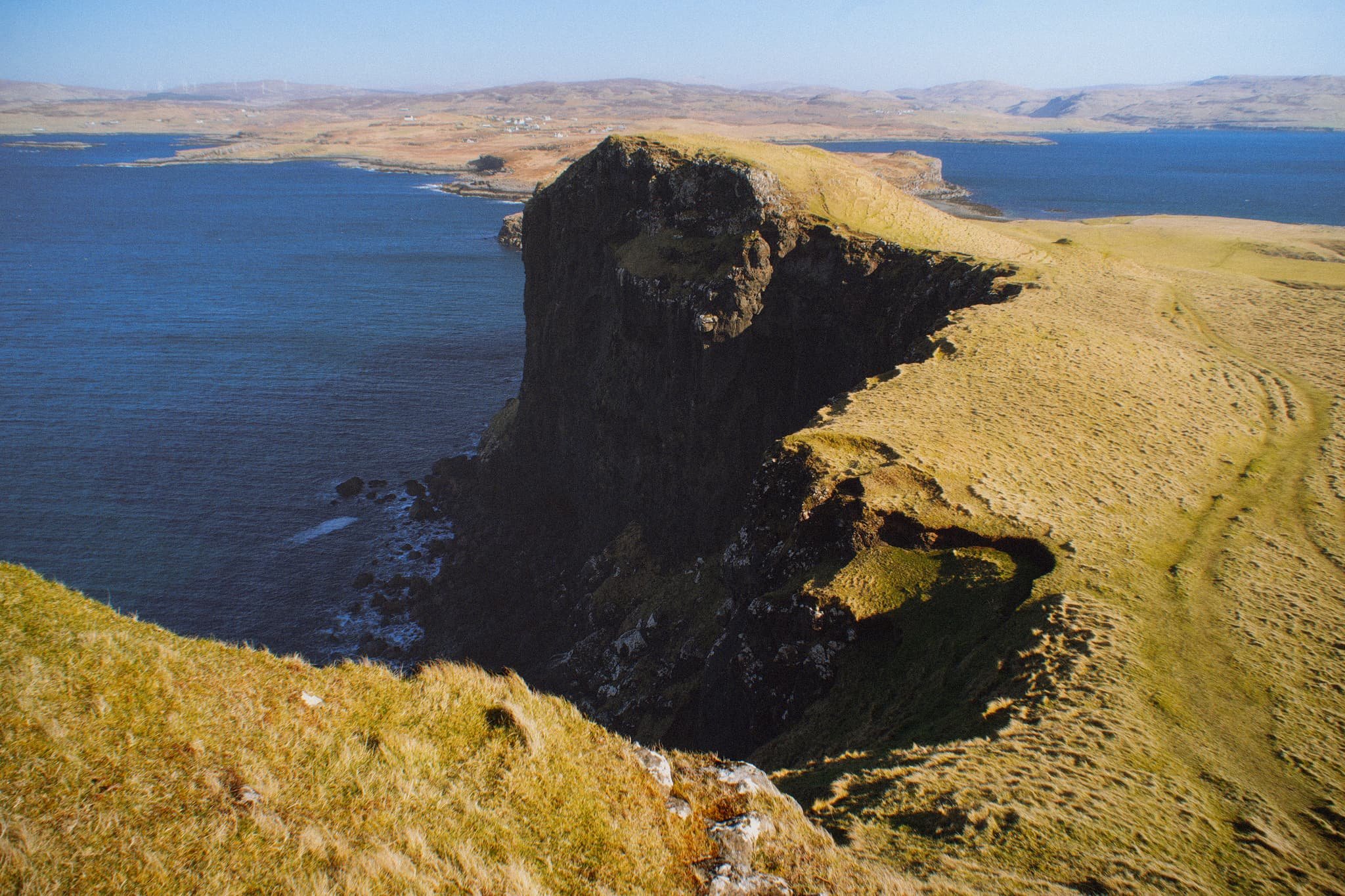
Once on the island it’s simple enough to navigate your way towards the highest cliffs. Once there, you get stunning views like this. Zoomed in, the island of Wiay is clear and you can even make out the cliffs and sea stacks of MacLeod’s Maidens.
Looking further east, the eastern end of Wiay gives way to the two distinctive flat-topped hills on the Duirinish peninsula, known as MacLeod’s Tables. The one on the left―MacLeod’s Table South or Healabhal Bheag―is 489 m/1,604 ft. The one on the right―MacLeod’s Table North or Healabhal Mhòr―is 469 m/1,538 ft.
From Oronsay’s tallest cliff, the view northeast down the island and across the loch all the way to Skye proper is just stunning.
Looking back at the tallest cliff, it’s contrasty shape and shadow is used to frame the distant island of Wiay and Duirinish cliffs.
My little Lisabet hiking her way up to the next cliff, whilst I shuffled as close as I dared to the precipitous edge for this monstrous view.
A simple leading line of Oronsay’s cliff edges, all the way back to Ullinish and the moorlands of Skye.
Returning to the lowest part of Oronsay, I venture around its more boggy eastern area for a view back to the craggy cliffs, again using the harsh light and shadow to aid in a leading line composition.
Did you enjoy these photos?

Portree, Isle of Skye, Scotland, Spring
For our 1st full day in Skye, we gradually eased ourselves in.
For our 1st full day in Skye, we gradually eased ourselves in.
Driving 7–8 hours can take it out of you.
So, with pleasing light conditions, we aimed straight for arguably the island’s main settlement, Portree. There’s a fairly well-known hike one can do from Portree, known as the Scorrybreac circuit. You head northeast out of town, take the coastal path below the cliffs of Ben Chracaig, navigate around the corner at Sgeir Mhòe, and follow the coastline towards Toravaig, with magnificent views down the Sound of Raasay and the cliffs of Sìthean a’ Bhealaich Chumhaing. Then it’s a question of hiking up the sharp ascent to Ben Chracaig and onto the path and road back down to Portree.
The views and light around the walk were stunning. Glamaig of the Red Cuillins was coated in snow and clear as a bell.
All photos taken on my Sony α7ii using my Pentax SMC 28mm F3.5 prime lens and Vivitar “Series 1” 70–210mm f2.8–4.0 zoom lens. RAWs developed in Lightroom, then edited and finalised in Photoshop.
Portree, Isle of Skye, Scotland, Spring by Ian Cylkowski is licensed under CC BY-NC-SA 4.0![]()
![]()
![]()
![]()
Upon our arrival at Portree, and parking up at the main car park, the views down Loch Portree towards the snowy Cuillins were already staggering. I quickly attached my longest lens and went snappy happy as the lighshow was constantly changing.
Our goal was to follow the coastal path below the left hill. But before we could get on that, this scene opened in front of me, putting me in mind of the fjords of Norway. I zoomed all the way to 210mm to get a real tight composition, involving the flanks of Ben Chracaig to the left, the crags of Ben Tianavaig to the right, and the hills of the Isle of Raasay in the middle.
On the trail, the sound of rushing water caught our attention. We quickly nipped off trail and followed the sound, locating this beautiful and totally unexpected waterfall! These unnamed falls belong to the River Chracaig as it tumbles down the hills above.
As we rounded the corner at Sgeir Mhòr, this magnificent view down the coastline to the illuminated cliffs of Sìthean a’ Bhealaich Chumhaing appeared.
We followed the trail further down the coastline until it abruptly turns inland near this area of flat land. The path then zigzags up the steep hillside of Ben Chracaig. Halfway up, lighting conditions changed and I quickly nabbed this dramatic shot.
Away from the cliffs and onto the moorland above Portree, this frankly ridiculous scene revealed itself to us. The Storr, lightly dusted in snow, with a thick and dramatic storm above, whilst the Portree moorlands and this house receive a strong burst of sunlight from behind us.
Back at Portree the light continued to change dramatically, with the clouds lifting above the Cuillins. I zoom in tight on this composition of Portree harbour as the light broke through the clouds enough to highlight the snowy Cuillins.
Did you enjoy these photos?

Staffin, Isle of Skye, Scotland, Spring
The sheer variety along Skye’s coastline is ridiculous.
The sheer variety along Skye’s coastline is ridiculous.
Basalt columnar cliffs? Billion-year old boulders? White sand? Knife-edge sea stacks? Waterfalls? Sea caves? Skye’s got it all.
And—at An Corran, Staffin—there is the “Jurassic coast”.
As I’ve mentioned on this site before, Staffin’s An Corran gained national attention in 2002 when a local couple walking along the coast noticed a large three-toed lizard-like footprint in a slab of rock. Further exploration uncovered additional dinosaur footprints. Turns out that were likely produced by a creature akin to a Megalosaurus. These fossils are estimated to be around 160 million years old, which makes them the most recent dinosaur relics found in Scotland.
This is the main draw of An Corran. But for us, we were more interested in the cliffs and the coastline.
All photos taken on my Sony α7ii using my Pentax SMC 28mm F3.5 prime lens. RAWs developed in Lightroom, then edited and finalised in Photoshop.
Staffin, Isle of Skye, Scotland, Spring by Ian Cylkowski is licensed under CC BY-NC-SA 4.0![]()
![]()
![]()
![]()
Below the cliffs at An Corran, the rocky coastline is dotted with giant boulders, often situated on top of raised platforms. Millennia of coastal and wind erosion have carved them into fantastic shapes.
As the tide was out, we were able to fully explore the revealed geology of An Corran’s coastline. I enjoyed myself immensely, a veritable playground of geometry, leading lines, light and subjects to play with.
Beautifully sculpted and layered formations give a glimpse of time way before the dawn of humans. In the distance, Staffin island is bathed in golden light.
Picking my way around slippery slabs, moss, and seaweed, I lined up this composition of the raised boulder, with the basalt cliffs in the distance.
Even closer to the boulder, I was able to obtain a reflection of sorts in a rock pool.
This particular boulder I find amazing. No human intervention whatsoever. A chunk of rock broke off the nearby cliffs, rolled down onto the coastline. Over the course of aeons, water and wind washed and carved the surrounding rock, leaving this boulder sitting on its protected pedestal.
Amongst all the ankle-breaking fist-sized pebbles, this arrangement of stones caught my eye.
Further towards the northwest side of An Corran, the rocky coastline gives way to sand. I carefully navigate around, seeking a composition of these embedded boulders in the sand.
At the far northwestern edge of the beach, a crackin’ view of the Quiraing opens up. I relied on the sensor stabilisation of my camera to slow down the shutter as much as possible at f/22, whilst still getting a relatively sharp image. The result came out alright.