Dovedale, Peak District, Autumn
From the Dark Peak to the White.
From the Dark Peak to the White.
In my last post, I talked about how the Peak District can be broadly split into two areas: the Dark Peak and White Peak. They reflect the predominant underlying geology: gritstone for the Dark Peak, and limestone for the White Peak.
After exploring the Dark Peak’s Froggatt and Curbar Edges, it was time to navigate the deep valley of Dovedale in the White Peak.
Dovedale is a particularly famous area in the Peak District—and the UK in general—seeing around 1 million tourists a year. It features stepping stones, rocky spires, craggy hills, and caves.
We elected to hike the full route, south to north, from the main car park to Milldale and back. In my view, Dovedale exceeded spectations.
All photos shot on my Sony α7ii using my Sony FE 28–70mm f3.5–5.6 OSS zoom and Rokinon 14mm f2.8 ED AS IF UMC prime lenses. RAWs were developed and edited in Lightroom for iPad, and finalised with the help of Darkroom for iPad.
Dovedale, Peak District, Autumn by Ian Cylkowski is licensed under CC BY-NC-SA 4.0![]()
![]()
![]()
![]()
Upon entering the valley, it became immediately apparent how steep and craggy the valley sides were.
Arguably Dovedale’s most recognisable landmark, the stepping stones. Used to cross the River Dove and continue up the valley. This photo was unfortunately timed. I waited for this composition, looking for someone to cross the river to provide context for the photo. Instead, I managed to snap the moment just before this poor gentleman fell into the river. He wasn’t hurt, thankfully, and was quickly helped out.
Further into Dovedale and glorious autumn colours revealed their hues in the woods of the valley.
The first tastes of what was to come. This limestone spire is part of the Tissington Spires that line the eastern side of the valley past Lover’s Leap.
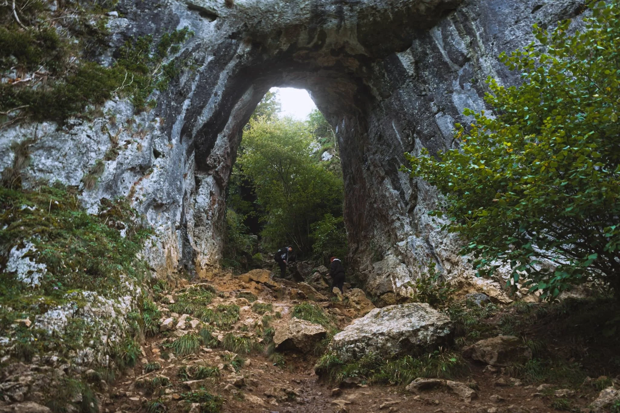
We paid particular attention to finding this spot, and were not disappointed. Beyond Tissington Spires an inconspicuous trail branches off the main valley footpath. It climbs up the steep valley side, revealing this monumental scene: a limestone archway, beyond which is Reynard’s Cave. A stupendous scene.
Beyond Raynard’s Cave, Dovedale narrows and deepens further into an area known as the Straits. Passage is possible only via a raised boarded trail. Once off the boards, we noticed a small cave with a clear and tempting stream trickling out of it.
The most accessible, and driest, caves in Dovedale are the Dove Holes, pictured here high above the trail.
Another solitary limestone spire pierces the sky above the woods.
The Dove Holes caves. They were formed during the last two ice ages by glacial water erosion. The caves became dry as the meltwater and river cut deeper into the gorge.
I got closer to the caves with my ultra-wide angle lens attached. It’s easy to imagine various ancient peoples and cultures have used these caves as shelter and storage.
The other, bigger, cave of Dove Holes, separated by a spire.
At Milldale, we paused for lunch and took the opportunity to wander around this bonny little village.
Milldale probably got its name from the corn mill that once stood on the River Dove here. Nowadays, it’s a sleepy little village with old stone cottages. Proper lovely.
After lunch it was time to take the return trip back down south the valley. This scene very much put me in mind of something like Yosemite.
One of the more famous spires in Dovedale can be seen on the right: Ilam Rock. Facing it is Pickering Tor. Ilam Rock rises 80 ft high from the valley floor, and is an impressive sight from any angle.
Near the Tissington Spires, Jacob’s Ladder rises above the woodland and catches the late afternoon light.
From below, the Tissington Spires are an imposing sight. Here they catch the golden afternoon light as the valley floor recedes into cold shadow.
Nearing the stepping stones once again, Dovedale’s most famous peak—Thorpe Cloud—comes into view. Here I took two exposures: one with my thumb covering the sun and one unobstructed. Blocking the sun with my thumb allowed me to blend the exposures with minimal lens flare.
Thorpe Cloud is an impressive pyramidal peak from across the River Dove.
One final look back into Dovedale before exiting for the day. An absolutely spectacular place.
Did you enjoy these photos?

Kingsdale, Yorkshire Dales, Autumn
Flexibility can lead to great things.
Flexibility can lead to great things.
We started a promising Saturday morning with a plan to hike up the highest peak in the Yorkshire Dales: Whernside (736 m/2,415 ft).
It would definitely be the highest peak we’ve ever ascended but we were planning to “cheat” a little bit. Below Whernside’s western flank is a valley called Kingsdale. There’s a road that runs from the south, near Ingleton, through and over Kingsdale before dropping back down into Dentdale. This road enjoys a few large passing places, one of which is near the summit of the road at 468 m a.s.l. In theory, we could park at the passing place and hike the minor trail up Whernside’s western flank to reach the summit, with only 300 m of actual ascent needed.
We didn’t go for it in the end. Parking in passing places is generally a no-no, and the trail and landscape around Whernside’s western flank looked rather boggy.
Instead, we drove back down to the valley bottom of Kingsdale and stopped at an actual parking place. Here we elected for a hike up Kingsdale’s magnificent limestone fellside to locate the magnificent Cheese Press Stones.
It turned out to be a great idea on a beautiful day.
All photos shot on my Sony α7ii using my Sony FE 28–70mm f3.5–5.6 OSS zoom lens. RAWs developed in Lightroom using RNI Films’ Kodachrome film profiles, finalised in Photoshop.
Kingsdale, Yorkshire Dales, Autumn by Ian Cylkowski is licensed under CC BY-NC-SA 4.0![]()
![]()
![]()
![]()
Straight away from our little parking bay, the views across to Twistleton Scar and Ingleborough were magnificent. They were only going to get better.
The road north through Kingsdale, with the valley’s fantastic scar looming directly above. The main scar above the road is known as Keld Head Scar. The start of the hike heads up the fellside just as the road veers right.
Part way up Keld Head Scar, and a single tree growing out of a limestone boulder provides a nice subject with Whernside in the distance.
As we clamber through the irregular clints and grikes of limestone, and navigate the occasional boulder, Ingleborough emerges from above Twistleton Scar. An old drystone sheep pen provides a nice foreground subject contrast against the fell in the distance.
A large cluster of limestone boulders, no doubt dumped in position by the last Ice Age, provide a nice foreground focal point. They also, happily, seem to “point” towards Ingleborough.
Finally, after a fairly challenging hike and scramble through Keld Head Scar, we emerged onto a limestone plateau where we easily spotted the Cheese Press Stones. These are a pair of giant limestone boulders, probably deposited here after the last Ice Age. Why are they called the “Cheese Press Stones”? No idea.
The boulder on the left is a good 9–10 ft tall. Some estimate its weight at around 15 tons. Here, an obvious composition is hard to ignore, using the two boulders to centre and frame Ingleborough.
A few yards away, I spot another interesting limestone boulder, which appears to me almost like a cracked open egg.
Further up the plateau, a group of large limestone boulders attract my attention. I line a composition, attempting to fill the frame with them whilst keeping Whernside visible in the distance.
I circle around the cluster of boulders to find a composition featured Ingleborough. It means shooting directly into the sun, but thankfully Sony RAW files are incredible flexible.
I locate Lisabet near North End Scar, perched atop a small crag, happily editing her photos. In the distance, the Forest of Bowland is just about visible.
The way back involves navigating this ankle-breaking limestone pavement to relocate the minor trail, which takes you below North End Scar, past Tow Scar, and back down to the road.
Beneath North End Scar’s western edge, the layering and striations of the limestone is fascinating.
I am a sucker for a good drystone wall composition.
The criss-crossing and weaving of the valley and its various limestone scars and layers provide me a delightful photo with Whernside high in the distance.
Nearly back at the car, with the limestone scar of Kingsdale’s western edge in full display. A beautifully sculpted glacial valley.
Did you enjoy these photos?
Ogwen Valley, Snowdonia, North Wales, Spring
The morning of my 40th birthday.
The morning of my 40th birthday.
We got up before the sun, devoured breakfast, and head straight into the heart of Yr Eryri for one of my favourite areas in the whole of North Wales: the Ogwen Valley.
Dyffryn Ogwen separates two mountain ranges: the Glyderau and the Carneddau. In the Glyderau you can find my favourite peak in all of Wales: Tryfan. She rises 3,010 ft and is often cited as one of the most recognisable mountains in Britain. My favourite compositions of Tryfan involve shooting it from the various falls and cascades of Afon Lloer across the valley.
As an additional bonus, we then enjoyed the Cwm Idwal circuit, taking in one of the most spectacular hanging valleys I know.
The light and weather could not have been kinder.
What a way to see in my 40th year on this planet.
All photos taken on my Sony a7ii using my Vivitar “Series 1” 28–105mm f2.8–3.8 and Rokinon 14mm f2.8. RAWs developed in Lightroom for iPad, then edited and finalised in Affinity Photo 2 for iPad.
Ogwen Valley, Snowdonia, North Wales, Spring by Ian Cylkowski is licensed under CC BY-NC-SA 4.0![]()
![]()
![]()
![]()
I finally got the composition of Tryfan I’ve been after for years. Tryfan at sunrise, with the cascades of Afon Lloer leading the way down the flanks of Pen yr Ole Wen.
Heading back down to the valley floor, a dry stone wall gives me another lovely composition involving Tryfan.
Beyond Tryfan, we climbed up the trail to take the Cwm Idwal circuit. I were very much hoping the light and conditions to be right enough so that the rising sun would illuminate the Idwal Slabs high above the tarn. Here, Castell y Geifr catches the rising sun above Cwm Idwal.
As we pottered about the shore of Llyn Idwal seeking out more compositions, what I hoped for finally happened. The Idwal Slabs, those towering cliffs of crag, starting catching the light. So I lined up this composition.
A tighter composition focusing on the Idwal Slabs. Arguably, Cwm Idwal’s most recognisable feature is the Devil’s Kitchen, or Twll Du (“black hole”) in Welsh. This is a large crack in the cliffs of Cwm Idwal, inside which flows a multi-drop waterfall. The light angle was just right.
As we circumambulated Llyn Idwal clockwise, I kept my gaze locked high on the crags above, watching the light change. As one of the many falls was lit up, I shot this moody photo.
The Cwm Idwal circuit is largely paved, making the going easy. As we neared the apex of the trail, another scene of delicious light demanded by attention.
Walking along the western section of the trail away from the Idwal Slabs, the profile of Pen yr Ole Wen (978m/3,209ft) comes into view. Here, I spot two giant slabs of rock that provide a nice foreground interest as Pen yr Ole Wen gets some lovely morning light.
A glacial erratic nearly blocks the trail. It also gives a lovely foreground interest against the emerging morning light drenching Pen yr Ole Wen.
Nearly at the start of the Llyn Idwal circuit, the tarn is calm and flat enough to give a lovely reflection of Wales’ 7th highest mountain.
Did you enjoy these photos?
Aber Falls, Snowdonia, Spring
Much like South Wales, North Wales and Snowdonia has its fair share of waterfalls.
Much like South Wales, North Wales and Snowdonia has its fair share of waterfalls.
One such waterfall we’ve never visited before, and was relatively close to where we’re staying for the week, is Aber Falls, just south of the village of Abergwyngregyn.
For most people, this involves a very simple walk from the Nature Reserve car park to the falls. But there is a second waterfall, less visited, that we decided to check out too.
The late afternoon/early evening gave us glorious light to work with, and the scale of the waterfalls were a sight to behold.
Photos taken on my Sony a7ii using a Vivitar “Series 1” 28–105mm f2.8–3.8 zoom and Rokinon 14mm f2.8 prime lenses. RAWs developed in Capture One for iPad, then edited and finalised in Affinity Photo 2 for iPad.
The falls are very popular. Accompanying us on the walk to Aber Falls were a large group of overseas students enjoying the delights of Wales. The falls can be seen from miles away.
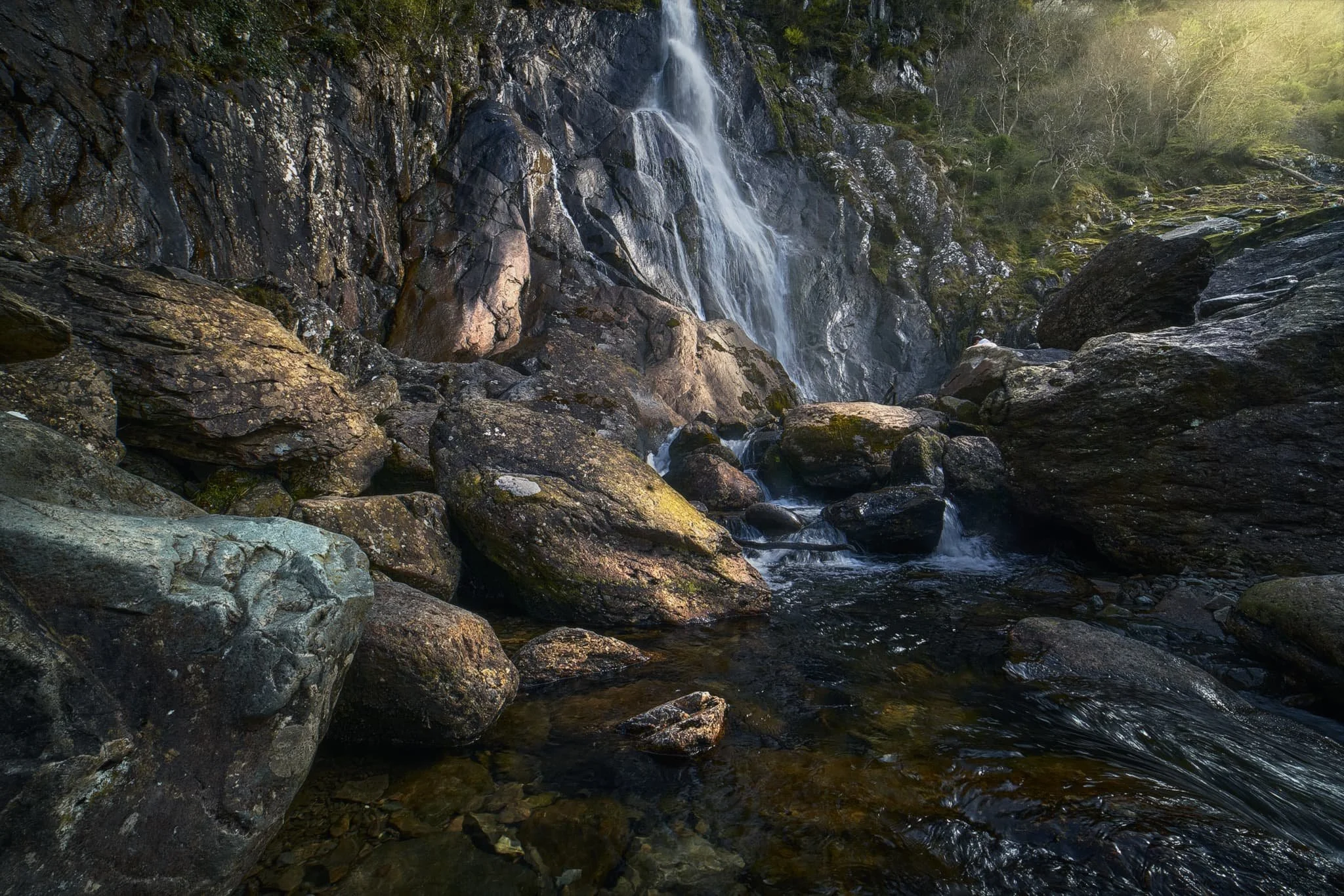
We made it to Aber Falls in no time and began scrambling around the boulders, seeking compositions of this 120ft waterfall plunging into its pool.
Of course, we weren’t the only ones at the falls, so patience was required to shoot photos when people left the frame. Additionally, I shot many exposures to really push the limits of how slow I could get the shutter speed whilst handheld. The Sony a7ii served me well.
Further along the head of the valley one can find another, less-visited, waterfall. This is Rhaeadr-bach or Rhaeadr Fach, which essentially means “smaller waterfall”, with Aber Falls technically named Rhaeadr-fawr, or “bigger waterfall”. This smaller waterfall had hollowed out a perfect little raised pool before dropping further into the river.
Did you enjoy these photos?

Glen Nevis, Lochaber, Scotland, Winter
The grandest valley beneath the tallest mountain.
The grandest valley beneath the tallest mountain.
The last time we visited Glen Nevis was way back in Autumn 2014, which was our very first time in the Glencoe/Lochaber area. This was in the prime of my HDR days.
Almost 10-years on, we returned with greater fitness and better vision. We elected to take the valley bottom riverside walk from the Ben Nevis Visitor Centre all the way to Polldubh falls and back. A solid 12–13km hike.
The section from the visitor centre to Polldubh falls was definitely not fun in places; the trail often became indistinct, with areas of sludgy bog and slippery mud. Nevertheless, the views were simply astounding wherever you looked, and we were blessed once again with glorious weather.
Photos taken on my Fujifilm X-T2 using my Vivitar “Series 1” 28–105mm f2.8–3.8 zoom and Laowa 9mm f2.8 ultra-wide lenses. RAWs converted in Capture One for iPad, developed using RNI Films’ Kodachrome film profiles, and finalised in Affinity Photo 2 for iPad.
Glen Nevis, Lochaber, Scotland, Winter by Ian Cylkowski is licensed under CC BY-NC-SA 4.0![]()
![]()
![]()
![]()
A relatively new and modern bridge crosses the River Nevis from the visitor centre and leads you along the riverside trail. A lot of people take this route to begin their ascent up all 1,345 m (4,413 ft) of Ben Nevis.
Following the riverside trail, the view down the glen opens up and reveals the massive shape of Sgùrr a’ Mhàim (1,099 m/3,606 ft). Its name means “rocky peak of the rounded hill”.
Despite the bright winter sun, it was still cold enough in the shade to freeze the water running down the valley sides.
After navigating a meander in the river, the neighbour of Sgùrr a’ Mhàim becomes visible: Stob Bàn (999 m/3,278 ft), which means “white peak”.
Nearing Polldubh falls, the path climbs up and away from the river. Doing so revealed this delightful composition towards Sgùrr a’ Mhàim, which I had to nab.
An abandoned, white-washed cottage. I don’t know if it’s used as a mountain bothy now or not.
Polldubh falls, with upper Glen Nevis in the distance. Quite an arresting sight, and developing a powerful waterfall.
Sgùrr a’ Mhàim is often mistaken to have snow around its peak. In fact, it’s usually white quartz you can see, which gives the mountain its lighter capped colour.
Heading back up the glen from the falls, the craggy shoulders of Meall an t-Suidhe (711 m/2,333 ft) are drenched in late afternoon winter sun.
I couldn’t resist this road shot featuring the two towering giants at the head of the glen. The road was quiet enough to allow us to walk alongside it all the way back to the visitor centre.
One last look back at Sgùrr a’ Mhàim before returning the visitor centre.
A challenging walk, in places, but a grand experience nevertheless.
Did you enjoy these photos?

Llyn y Fan Fach, Brecon Beacons, South Wales, Autumn
If I had one main personal goal for this fortnight in South Wales we’re enjoying, it’s to get up one of the mountain ranges in the Brecon Beacons National Park.
If I had one main personal goal for this fortnight in South Wales we’re enjoying, it’s to get up one of the mountain ranges in the Brecon Beacons National Park.
There’s a few mountain/hill ranges in the Brecon Beacons National Park, the main two I was interested was either:
The Brecon Beacons, at the heart of the national park, which includes South Wales’ highest peak Pen y Fan (886 metres/2,907 feet)
The Black Mountain, sometimes known as the Carmarthenshire Fans.
On this occasion, we elected to hike up the Black Mountain range above the mountain tarn known as Llyn y Fan Fach.
The day promised to be glorious, with puffy white clouds and strong sun in the crisp autumn air. Though we were disappointed at the sight of Llyn y Fan Fach halfway up the climb (it seems to be in the process of being emptied), the views on the way up to the peaks were absolutely astounding.
All photos taken on my Fujifilm X-T2 using my Vivitar “Series 1” 28–105mm f2.8–3.8 zoom and Laowa 9mm f2.8 prime lenses. RAWs converted in Capture One for iPad, developed and finished in Affinity Photo for iPad.
Llyn y Fan Fach, Brecon Beacons, South Wales, Autumn by Ian Cylkowski is licensed under CC BY-NC-SA 4.0![]()
![]()
![]()
![]()
After exiting a busy car park we started the ascent up the Beacons Way path direct towards the tarn. Looking to the east I nabbed this quick shot of the criss-crossing hills towards Bryn Blaen-Wysg.
About halfway up the path is a small hut where the dam is. Above it are these fish hatcheries which were originally used as filter beds. The rounded hills at the bottom of the path are in stark contrast to the shapes of the Black Mountain, as you’ll see.
As we climb the views get ever more extensive. The last time we visited Llyn y Fan Fach, back in October 2018, there were few people around. This time the car park was full and cars had been dumped on the grass verges along the road leading to the car park. Apparently this area became vastly more popular after being featured in a 2020 TV series “Secrets of Britain”.
From the left, Fan Brycheiniog and Picws Du come into view, with their heavily glaciated and steep northern craggy faces. Morning sun was attempting to break through the clouds above.
Wow, am I right? After seeing the state of Llyn y Fan Fach, we quickly continued our ascent up the Black Mountain. The views looking back to the peaks were too incredible to ignore. The tallest peak, Fan Brycheiniog, is on the left, or strictly speaking its “nose”, Fan Foel. This is followed by Picws Du, Cefn Twrch, and Waun Lefrith.
The hike up the western slopes of the Black Mountain is steep, and the drop down to the tarn is sheer… but I mean, look at those views. The light got more intense, too, as the clouds started to dissipate and reveal the sun.
These peaks are primarily composed of Old Red Sandstone, laid down around 400 million years ago, with bands of Carboniferous Limestone. I wanted to find some of the exposed red sandstone as a contrast to all the grass.
More cracks of ruby red sandstone which I wanted to emphasise with a vertical composition towards the Black Mountain peaks.
My lovely Lisabet, being immensely more brave than I as she stands atop an exposed crag with a 500ft sheer drop beneath her.
This was about as close as I dared go to those crags, with the beautifully curved glaciated wall of Waun Lefrith in the distance.