Rydal Water, Lake District, Spring
The Lake District is known for many things.
The Lake District is known for many things.
Its lakes, of course. The fells. All the valleys. But also William Wordsworth, who was born in Cockermouth and called the Lake District home for much of his life. It was in the Lake District, wandering along the shores of Ullswater, that Wordsworth took inspiration from the plethora of daffodils along the lake’s shoreline, which ultimately resulted in his most famous poem, “I Wandered Lonely as a Cloud”.
Conscious that the end of daffodil season was approaching, Lisabet and I embarked on a wee circuit around Rydal Water, which I knew to be home to plenty of daffodils. It did not disappoint. Spring is here.
On a separate note, this is also the last set of images taken on my trusty Fujifilm X-T2. With my 40th birthday fast approaching, my Dad did the unthinkable and got me a friggin’ camera for my birthday! A Sony α7ii. Full-frame goodness, here we go.
These photos were taken on my Fujifilm X-T2 using my Vivitar “Series 1” 28–105mm f2.8–3.8 zoom and Laowa 9mm f2.8 prime lenses. RAWs developed in Capture One for iPad, then edited and finalised in Affinity Photo 2 for iPad.
Around Rydal Water there are plenty of areas to choose from when it comes to picking out daffodils for compositions. After one failed attempt behind a bench where I went slip-sliding in the mud, I found this wee clump of yellow beauties and lined up a photo.
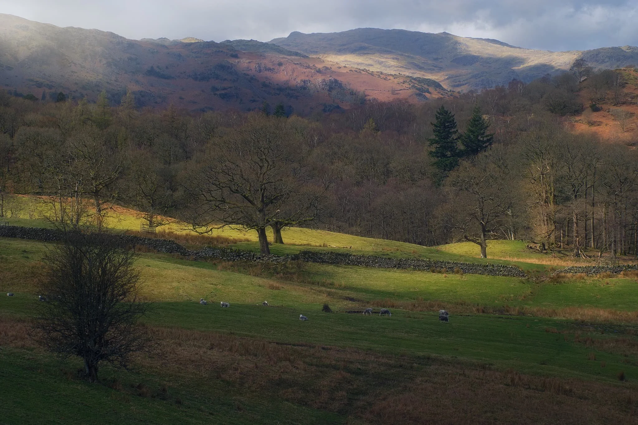
Lovely golden light slithers across the rolling fields and the Grasmere fells above.
Below Loughrigg Terrace, a dilapidated barn provides a nice subject looking back to the Ambleside fells.
Did you enjoy these photos?
Barnard Castle, County Durham, Spring
Apologies for the delay since my last post.
Apologies for the delay since my last post.
Things have been on the change again, personally. Also, this last week I’ve endured a rather nasty stomach bug. The less said about that the better.
A couple of weekends ago, Lisabet and I decided to move away from countryside-based adventures and check a wee little town you may have heard of (if you’re British and follow the news): Barnard Castle.
The charming historical town gained unfortunate notoriety in 2020 when Dominic Cummings, the chief advisor to the British Prime Minister, was found to have traveled there with his family during the first UK lockdown of the COVID-19 pandemic. Given his close contact with the infected Prime Minister, Cummings was at a substantial risk of carrying the virus himself (he exhibited symptoms the following day). Media accusations of violating lockdown rules emerged, to which Cummings explained that he had driven to the town to test his eyesight in order to reassure his wife of his ability to drive them back to London the next day.
Regardless of all of that, Barnard Castle sits in a beautiful area, which we explored to also take in the sights of the ruins of Eggleston Abbey.
A moody day for photography.
All photos taken on my Fujifilm X-T2 using my Vivitar “Series 1” 28–105mm f2.8–3.8 zoom and Laowa 9mm f2.8 prime lenses. RAWs developed in Capture One for iPad, edited and finalised in Affinity Photo for iPad.
Barnard Castle, Country Durham, Spring by Ian Cylkowski is licensed under CC BY-NC-SA 4.0![]()
![]()
![]()
![]()
The circular round tower of the Barnard Castle itself, one of the main features of the ruins that still stands. Daffodils lined the path around the ruins on a moody day.
Barnard Castle, the town, is chock-full of yards (alleys) like this, which always draw my eye for a photo.
We found the streets of Barnard Castle to be well kept, with plenty of independent shops and eateries, occasionally peppered with some more mainstream brands.
Below the castle ruins this handsome bridge caught a sliver of golden afternoon light.
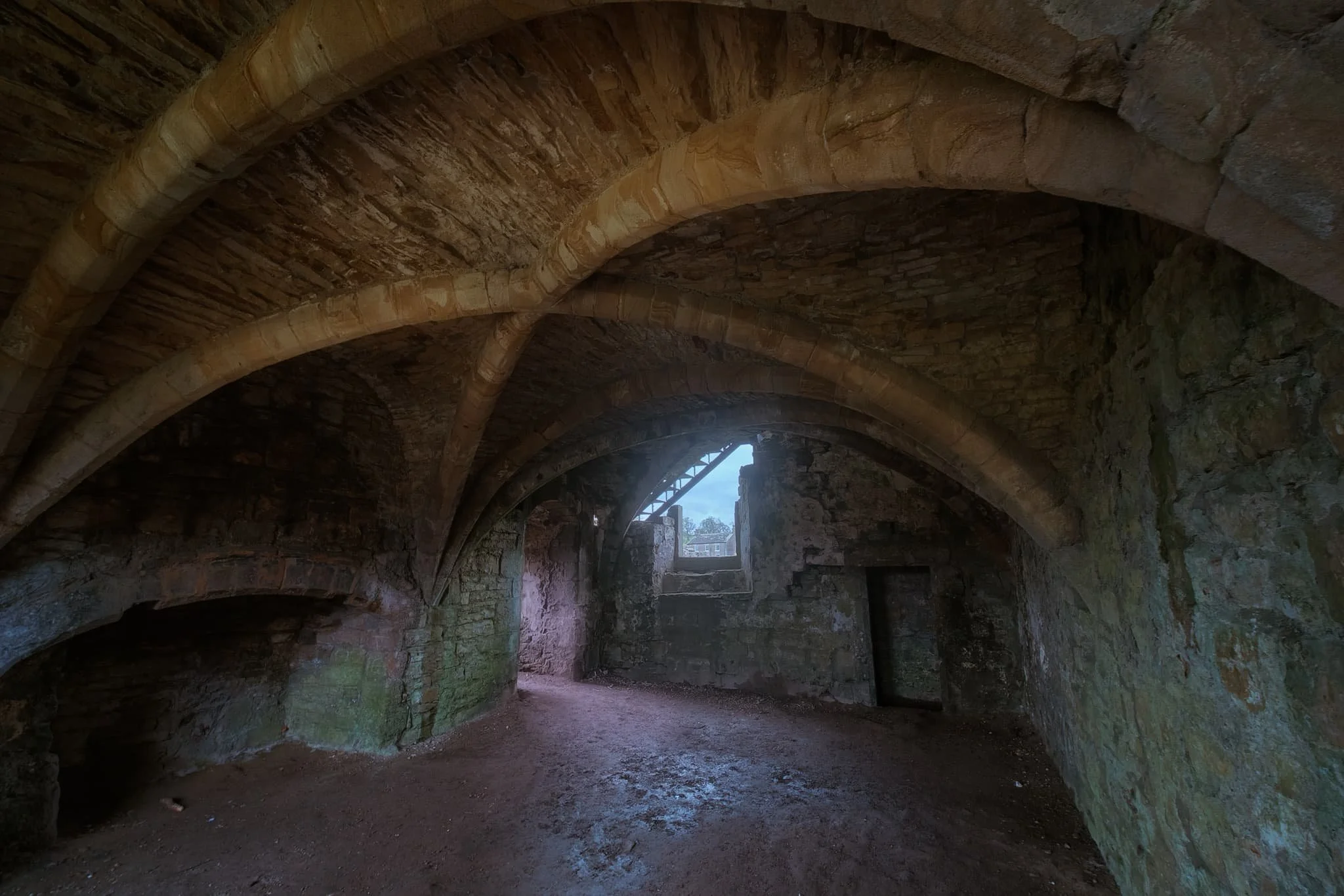
We followed the country road from Barnard Castle to Egglestone Abbey. The moody and changeable day followed us. Here a table-tomb pointed towards some of the last standing walls of the abbey ruins.
The abbey was constructed in the late 12th century by Premonstratensian monks. Like all other abbeys in England, it was dissolve din 1540 by King Henry VIII’s Dissolution of the Monasteries.
These days the ruins are in the custody of English Heritage, and access is free. I highly recommend a visit if you’re ever in the area.
Did you like these photos?

Stanley Ghyll Force, Lake District, Spring
After a sobering return from a beautiful week in the Highlands, it was time for a beautiful little jaunt in Eskdale.
After a sobering return from a beautiful week in the Highlands, it was time for a beautiful little jaunt in Eskdale.
I was also due to hang out with me Dad again. After arriving at Dad’s, he suggested checking out Stanley Ghyll Force, one of the Lake District’s largest waterfalls. I were game for that!
Stanley Ghyll Force is located in Eskdale, a gorgeous valley in the southwestern corner of the Lake District. The last―and only―time I visited Stanley Ghyll Force was back in 2017. I know this because I shot the waterfall with a Sigma dp0.
Back then, I was all on me own attempting to navigate a tricky gorge. However, on that occasion, I was able to get right to the bottom of the falls for some cracking.
A lot has changed in the intervening 5-6 years. For a start, you can’t get to the bottom of the falls anymore. The path has eroded and collapsed to the point that it’s too dangerous. Instead, the Lake District National Park have created an alternative route that scales up the sides of the gorge so that you can get above the falls. In addition, they’ve also cut back hectares of invasive rhododendron and constructed a fantastic viewing station above the gorge.
We enjoyed some fantastic light, and I had a grand day out with me Dad.
All photos taken on my Fujifilm X-T2 using my Vivitar “Series 1” 28‒105mm f2.8‒3.8 zoom, Super Ozeck 80mm‒210mm f4.5 zoom, and Laowa 9mm f2.8 ultra-wide prime lenses. RAWs developed in Capture One for iPad, edited in Affinity Photo 2 for iPad.
Stanley Ghyll Force, Lake District, Spring by Ian Cylkowski is licensed under CC BY-NC-SA 4.0![]()
![]()
![]()
![]()
The gorge that contains Stanley Ghyll Force is wonderfully mossy and vibrant. Here, a pocket of light illuminates a boulder field exposed in the woodland.
We passed a small tributary beck that was catching some wonderful light in the gorge.
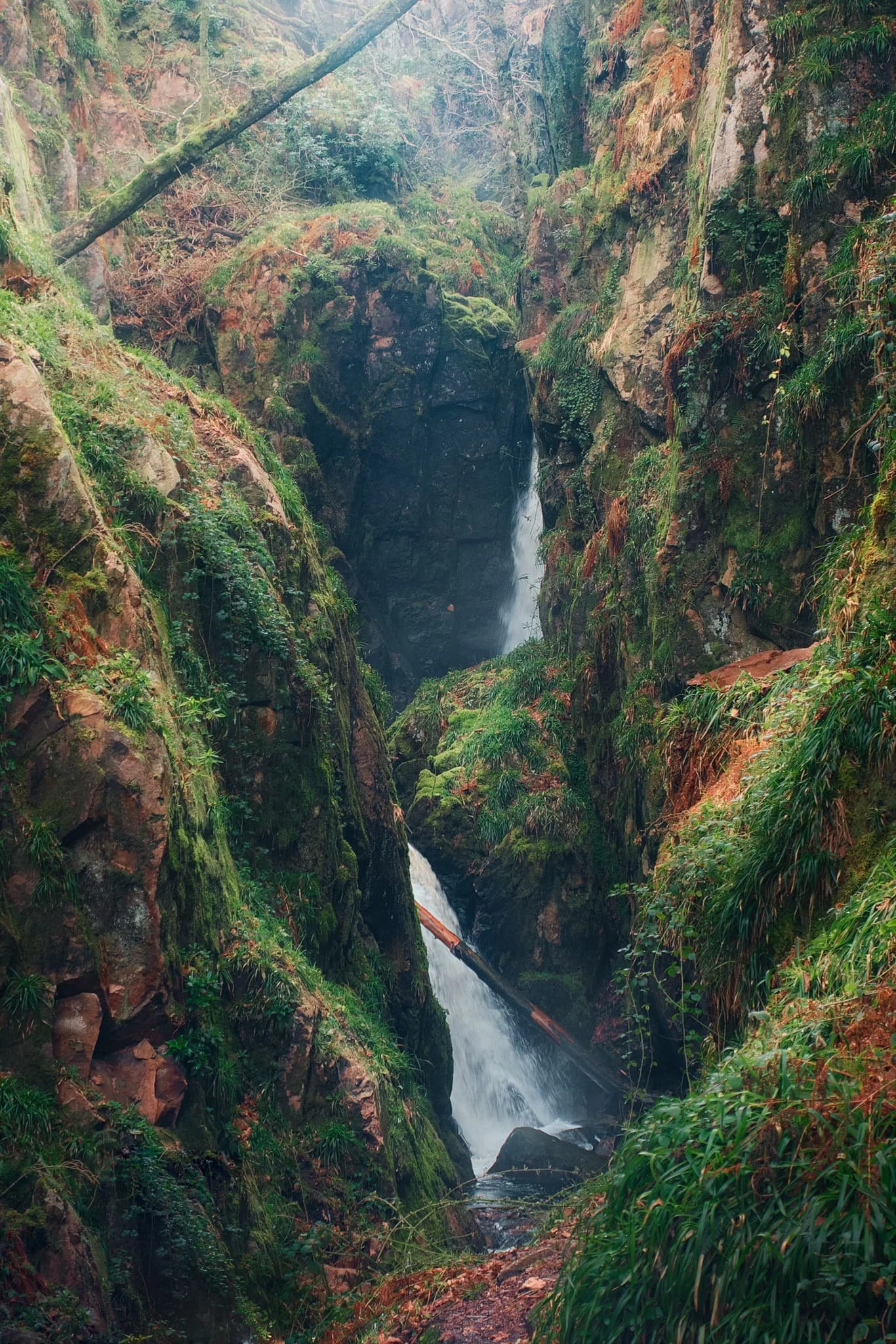
Eventually, the glory of Stanley Ghyll Force came into view. This was as close as we were allowed to get to it. Still some absolutely crackin’ light flooding into the gorge though.
After hiking up the new path made by the National Park, we found the new viewing station to check out the views it offered. And… wow. A sheer 150ft drop pulls your down the gorge and towards Stanley Ghyll Force. What a sight.
We followed the return track back down to the valley. As we did, me and Dad spotted some incredible light playing out on the distant Eskdale fells, and stopped to shoot photos like crazy.
Did you like these photos?

Kinlochleven, Lochaber, Scotland, Winter
Where to go on the final day of our week long Scottish Highlands getaway?
Where to go on the final day of our week long Scottish Highlands getaway?
We had a few options, but ultimately settled on an area we’d only visited once, the very first time we explored Glencoe in Autumn 2014: Kinlochleven.
Kinlochleven is a small village situated at the eastern end of Loch Leven and completely surrounded by massive mountains. The Loch Leven valley feels more like a Norwegian fjord; a small ribbon lake with mountains rising sheer from the water.
Last time we visited, we barely scratched the service of what there was to offer, largely because of how unfit I was. That situation is a bit different these days, so we embarked on a more more strenuous and adventurous hike.
It were glorious. A great day to end the week.
All photos taken on my Fujifilm X-T2 using my Vivitar “Series 1” 28–105mm f2.8–3.8 zoom lenses. RAWs converted in Capture One for iPad, developed using RNI Films’ Kodachrome film profiles, finalised in Affinity Photo 2 for iPad.
Kinlochleven, Lochaber, Scotland, Winter by Ian Cylkowski is licensed under CC BY-NC-SA 4.0![]()
![]()
![]()
![]()
One aspect of the Kinlochleven area we completely missed all those years ago was a large and very accessible waterfall. So this was the first thing to tick off the list. This is Grey Mare’s Tail, which plunges nearly 50m in a single drop. This scene, with a tiny Lisabet gazing upon the falls, put me in mind of some of the photographs I’ve seen of some of the Yosemite waterfalls.
After gingerly picking our way around the falls, it was time to begin the steep ascent up the flanks of Leachd na h-Aire to seek views of the loch and the mountains above it. It didn’t take long before we could see the magnificent shape of the Pap of Glencoe above the loch like a wizard’s hat.
Zooming in for a tighter composition of the Pap, using some of these lovely Scottish pines to the frame the scene.
After a slight wrong turn we used this deviation to our advantage by climbing up onto a small knoll that offered this spectacularly clear view of Loch Leven and her mountains. What a sight. The Pap of Glencoe to the left, and Beinn na Caillich on the right.
A small cluster of Scots pines provide a nice compositional aid, pointing upwards to the magnificent Pap of Glencoe. As the day went on, the light got better and better.
Our goal was to locate the now abandoned Mamore Lodge hotel, which has apparently been left to rot for a decade or so now. Along the way, I snapped one more composition of the Pap.
We finally arrived at the former hotel, and scanned around its perimeter. The lodge was originally built in 1903 for Capt. Frank Bibby, who made his fortune in the Liverpool shipping industry. The aluminium works company, whom essentially created the village Kinlochleven, apparently built the lodge in return for the grant of additional land to house workers back down in the village. Sad to see this.
From the abandoned Mamore Lodge, we were able to locate the small road and follow it all the way back down to the loch, happily snapping compositions along the way.
Beinn na Caillich catching some golden wintersun as we followed the winding road down to the loch shore.
Did you enjoy these photos?

Glenfinnan, Lochaber, Scotland, Winter
We were exceptionally fortunate with the Scottish Highland weather.
We were exceptionally fortunate with the Scottish Highland weather.
Although conditions were consistently near the freezing point, we enjoyed days of clear light and skies. The only day that wasn’t the case was when we hiked around Glenfinnan.
Glenfinnan is a place of great natural beauty as well as historical significance. It was here in 1745 that the Jacobite rising began. Prince Charles Edward Stuart (popularly known as “Bonnie Prince Charlie”) raised his standard here on the shores of Loch Shiel in the valley, in the hopes of retaking the British throne for his father, James Francis Edward Stuart.
Glenfinnan is also home to the 792 ft curve of Glenfinnan Viaduct, made famous in recent times for its inclusion in the Harry Potter films where the Hogwarts Express is seen crossing the viaduct in several of the films.
All photos taken on my Fujifilm X-T2 using my Vivitar “Series 1” 28–105mm f2.8–3.8 zoom and Laowa 9mm f2.8 lenses. RAWs converted in Capture One for iPad, developed using RNI Films’ Kodachrome film profiles, and finalised using Affinity Photo 2 for iPad.
Glenfinnan, Lochaber, Scotland, Winter by Ian Cylkowski is licensed under CC BY-NC-SA 4.0![]()
![]()
![]()
![]()
Our goal for the day was to hike the Viaduct Trail. As a circular route, you can start at practically any point. In our case, we began from the picturesque Glenfinnan railway station.
The route leaves the railway station via the woodland beneath it, and starts climbing back up the mountainside towards the viaduct. Here, Beinn an Tuim (810m/2,657ft) was catching a slither of morning winter light.
There are several points along the trail specifically constructed for hikers to enjoy some staggering views. When we arrived, Sgùrr Ghiubhsachain (849m/2,785ft) was being gently bathed in the morning’s rare light show.
Our first glimpse of the magnificent Glenfinnan Viaduct, as it curves its way beneath Mam a’ Chreagain.
We followed the trail down the mountainside for a closer look at the Viaduct. It was constructed between 1897 and 1898 by Sir Robert McAlpine. Built entirely out of concrete, it comprises 21 arches with spans of 49ft and reaches 100ft above the valley.
We came off the main trail to seek alternative viewpoints of the valley and the viaduct. Our reward was this fantastic criss-crossing view all the way up the Glen Finnan valley, with light scanning across the land.
This was the view I was after. The beautiful curve of the viaduct and Loch Shiel’s magnificent mountain backdrop in the distance. This image is made of 5 or 6 vertical shots stitched together to create this panorama.
Down at the shores of Loch Shiel stands the Glenfinnan Monument, erected 70 years after the failed Jacobite Rising of 1745. Atop the monument stands the Unknown Highlander.
Above the loch, the Church of St. Mary & Saint Finnan enjoys a fantastic vantage point of the loch and its mountains.
Did you enjoy these photos?
Oban, Argyll & Bute, Scotland, Winter
We’ve only ever been to Oban once before.
We’ve only ever been to Oban once before.
This was way back in Autumn 2014, when we first went into the Highlands of Scotland. On a particularly murky, misty, and wet day we drove away from the mountains and instead went to check out the nearest major town: Oban.
On that occasion, we were unimpressed. The place seemed drab and down on its luck.
On this trip, we decided to revisit Oban now that we had great light and clear blue skies. Oh boy, did we completely misjudge Oban. It’s a beautiful little town that enjoys terrific sea views across to Kerrera Island and the Isle of Mull beyond. It also enjoys lovely independent shops, top cafés, and gorgeous restaurants.
Amazing what better weather and 10 years can do.
All photos taken on my Fujifilm X-T2 using my Vivitar “Series 1” 28–105mm f2.8–3.8, Laowa 9mm f2.8, and Super Ozeck 80–205mm f4.5 lenses. RAWs converted in Capture One for iPad, developed using RNI Films’ Kodachrome film profiles, and finalised in Affinity Photo 2 for iPad.
Oban, Argyll & Bute, Scotland, Winter by Ian Cylkowski is licensed under CC BY-NC-SA 4.0![]()
![]()
![]()
![]()
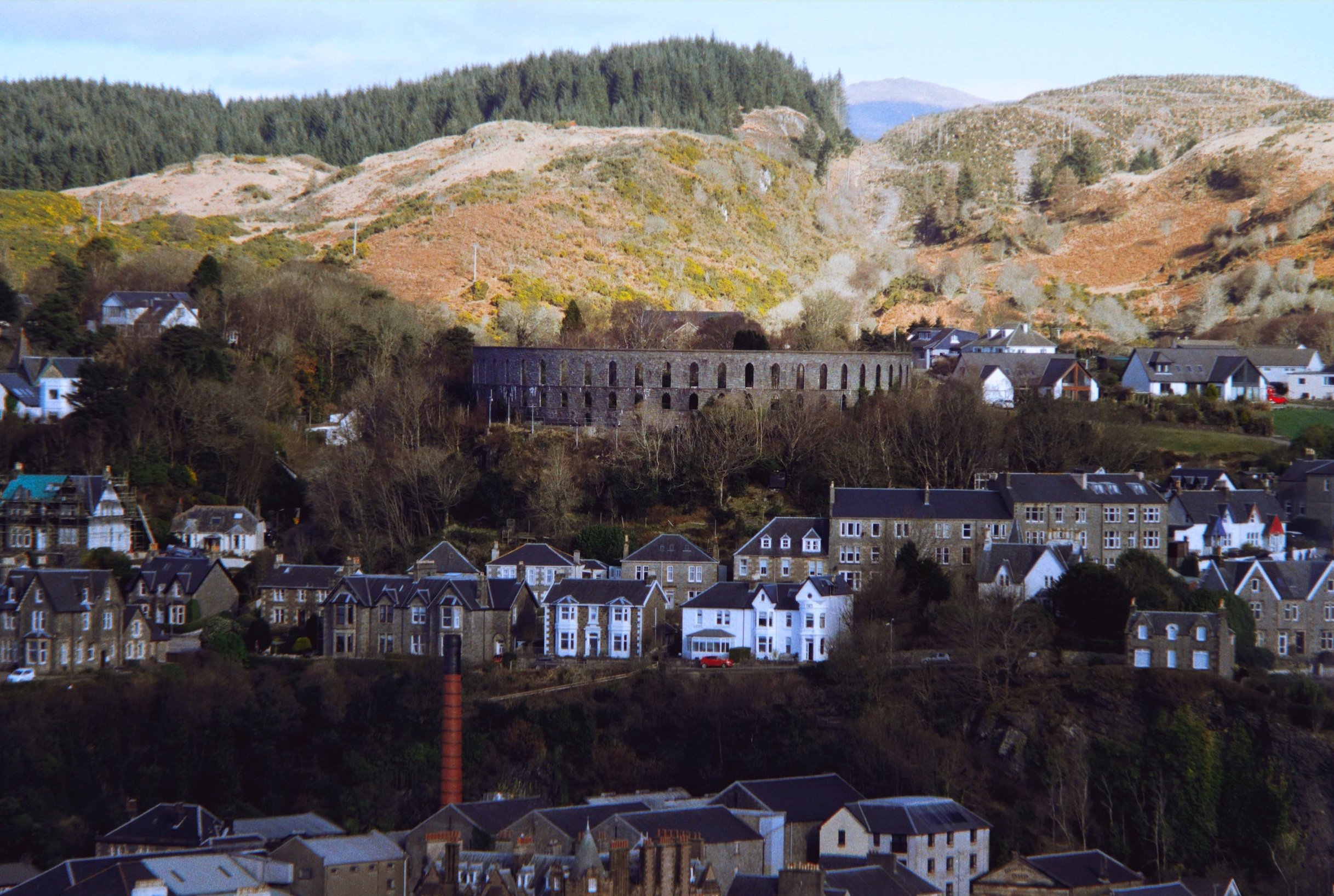
Round the corner from where we parked, Oban Distillery is a beautiful building. The distillery was established in 1794, before there was even a town around it.
Our first order of the day was to hike up the hill behind Oban to check out the area’s most well-known landmark, McCaig’s Tower.
The way to McCaig’s Tower. It was built in 1897, commissioned by wealthy banker John Stuart McCaig as a monument to his family and to provide work for the local townsfolk. He was also the tower’s architect.
Out of the tower’s western side, you can enjoy expansive views across the Inner Firth of Lorn towards Kerrera Island and the Isle of Mull. Regular ferry trips courtesy of CalMac are available to the various islands near Oban.
One of these days we’ll have to check out some of the small isles you can visit from Oban.
McCaig’s Tower has 94 lancet arches, one of which I utilised as a literal compositional frame towards the mountains on the Isle of Mull.
Mr. McCaig commissioned the building of the tower at a cost in 1897 of £5,000 Sterling… that’s over £500,000 in today’s money.
The tower was built between 1897 and 1902, when Mr. McCaig died of a cardiac arrest. Construction of the tower promptly stopped, with only the outer walls completed.
Mr. McCaig planned for a museum and art gallery with a central tower to be incorporated. Inside the central tower he wanted to commission statues of himself, his siblings and their parents. None of this happened due to his death and the contesting of his Will. Nevertheless, I like that inside the tower a garden has been allowed to form.
Back down at the shore we gently meandered around the town’s coastline, looking for shots before stopping for lunch.
After a delicious lunch at Ee-Usk (which included the freshest oysters I’ve ever had), our next plan was to head up another hill above the town: Pulpit Hill.
A short and sharp climb up onto Pulpit Hill gave us tremendous views of the town, like this. Even from here, McCaig’s Tower is easily visible, as is the Oban Distillery’s bright red chimney.

From this vantage point I hastily equipped me Super Ozeck 80–205mm zoom lens for long compositions. The day was so crisp you could even make out Ben Cruachan (1,126m/3,694ft), 26-miles away.
Zooming in across the Inner Firth of Lorn. Bottom left is the northern tip of Kerrera Island, followed by the tiny islet of Maiden Island in the centre. In the distance is the uplands of the Isle of Mull.
Along the northern coastline of Oban one can find the ruins of Dunollie Castle, which enjoys a great lookout towards the uplands on the Isle of Mull. There’s been a fortification where the castle sits since the Early Middle Ages, but the current ruins date from the 12th or 13th century.
A super-zoomed in shot of upper Oban, with McCaig’s Tower visible and the craggy uplands above.
Hutcheson’s Monument on Kerrera Island, acting as a beacon pointing the way towards the Isle of Mull.